You are here: Home > Network List > IW - Intermountain West Stations List
> Station MOOW Moose Ponds, Wyoming, USA > Earthquake Result Viewer
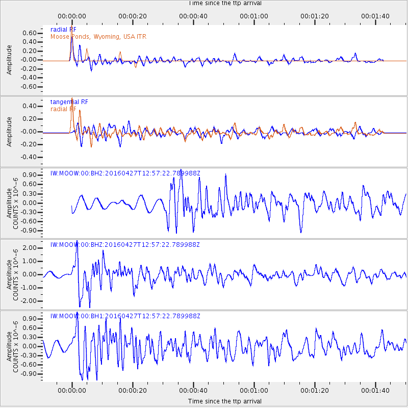
MOOW Moose Ponds, Wyoming, USA - Earthquake Result Viewer
*The percent match for this event was below the threshold and hence no stack was calculated.
| Earthquake location: |
Near Coast Of Chiapas, Mexico |
| Earthquake latitude/longitude: |
14.6/-93.0 |
| Earthquake time(UTC): |
2016/04/27 (118) 12:51:22 GMT |
| Earthquake Depth: |
35 km |
| Earthquake Magnitude: |
5.8 MB |
| Earthquake Catalog/Contributor: |
NEIC PDE/NEIC COMCAT |
|
| Network: |
IW Intermountain West |
| Station: |
MOOW Moose Ponds, Wyoming, USA |
| Lat/Lon: |
43.75 N/110.74 W |
| Elevation: |
2128 m |
|
| Distance: |
32.8 deg |
| Az: |
335.9 deg |
| Baz: |
146.937 deg |
| Ray Param: |
$rayparam |
*The percent match for this event was below the threshold and hence was not used in the summary stack. |
|
| Radial Match: |
75.98761 % |
| Radial Bump: |
400 |
| Transverse Match: |
76.28753 % |
| Transverse Bump: |
400 |
| SOD ConfigId: |
1475611 |
| Insert Time: |
2016-05-11 12:54:10.387 +0000 |
| GWidth: |
2.5 |
| Max Bumps: |
400 |
| Tol: |
0.001 |
|
Signal To Noise
| Channel | StoN | STA | LTA |
| IW:MOOW:00:BHZ:20160427T12:57:22.789988Z | 7.2694864 | 1.2681832E-6 | 1.7445292E-7 |
| IW:MOOW:00:BH1:20160427T12:57:22.789988Z | 3.5596097 | 6.1761426E-7 | 1.7350617E-7 |
| IW:MOOW:00:BH2:20160427T12:57:22.789988Z | 3.5205982 | 5.002669E-7 | 1.4209712E-7 |
| Arrivals |
| Ps | |
| PpPs | |
| PsPs/PpSs | |


