You are here: Home > Network List > TA - USArray Transportable Network (new EarthScope stations) Stations List
> Station A16A West Butte Ranch, Sweetgrass, MT, USA > Earthquake Result Viewer
A16A West Butte Ranch, Sweetgrass, MT, USA - Earthquake Result Viewer
| Earthquake location: |
Guatemala |
| Earthquake latitude/longitude: |
14.6/-91.2 |
| Earthquake time(UTC): |
2009/05/03 (123) 16:21:47 GMT |
| Earthquake Depth: |
124 km |
| Earthquake Magnitude: |
5.6 MB, 6.2 MW, 6.2 MW |
| Earthquake Catalog/Contributor: |
WHDF/NEIC |
|
| Network: |
TA USArray Transportable Network (new EarthScope stations) |
| Station: |
A16A West Butte Ranch, Sweetgrass, MT, USA |
| Lat/Lon: |
48.95 N/111.60 W |
| Elevation: |
1394 m |
|
| Distance: |
38.2 deg |
| Az: |
338.142 deg |
| Baz: |
146.852 deg |
| Ray Param: |
0.075282946 |
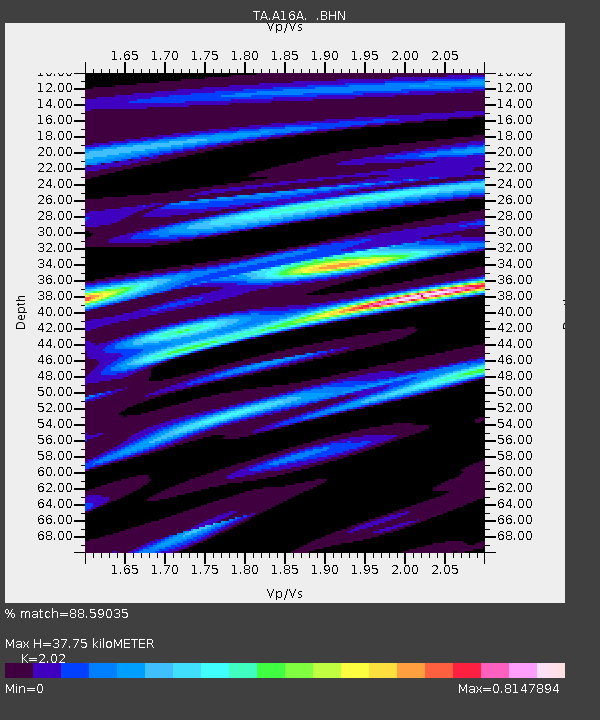
| Estimated Moho Depth: |
37.75 km |
| Estimated Crust Vp/Vs: |
2.02 |
| Assumed Crust Vp: |
6.242 km/s |
| Estimated Crust Vs: |
3.09 km/s |
| Estimated Crust Poisson's Ratio: |
0.34 |
|
| Radial Match: |
88.59035 % |
| Radial Bump: |
376 |
| Transverse Match: |
63.454758 % |
| Transverse Bump: |
400 |
| SOD ConfigId: |
2658 |
| Insert Time: |
2010-03-06 09:50:21.920 +0000 |
| GWidth: |
2.5 |
| Max Bumps: |
400 |
| Tol: |
0.001 |
|

Signal To Noise
| Channel | StoN | STA | LTA |
| TA:A16A: :BHN:20090503T16:28:24.049011Z | 7.746628 | 7.272016E-7 | 9.387331E-8 |
| TA:A16A: :BHE:20090503T16:28:24.049011Z | 4.4144745 | 3.949953E-7 | 8.9477304E-8 |
| TA:A16A: :BHZ:20090503T16:28:24.049011Z | 5.746327 | 3.6673316E-7 | 6.3820444E-8 |
| Arrivals |
| Ps | 6.5 SECOND |
| PpPs | 17 SECOND |
| PsPs/PpSs | 24 SECOND |


