You are here: Home > Network List > TA - USArray Transportable Network (new EarthScope stations) Stations List
> Station A16A West Butte Ranch, Sweetgrass, MT, USA > Earthquake Result Viewer
A16A West Butte Ranch, Sweetgrass, MT, USA - Earthquake Result Viewer
| Earthquake location: |
Near East Coast Of Honshu, Japan |
| Earthquake latitude/longitude: |
36.2/141.5 |
| Earthquake time(UTC): |
2008/05/07 (128) 16:02:02 GMT |
| Earthquake Depth: |
19 km |
| Earthquake Magnitude: |
5.7 MB, 6.2 MW, 6.2 MW |
| Earthquake Catalog/Contributor: |
WHDF/NEIC |
|
| Network: |
TA USArray Transportable Network (new EarthScope stations) |
| Station: |
A16A West Butte Ranch, Sweetgrass, MT, USA |
| Lat/Lon: |
48.95 N/111.60 W |
| Elevation: |
1394 m |
|
| Distance: |
73.3 deg |
| Az: |
41.199 deg |
| Baz: |
306.064 deg |
| Ray Param: |
0.053073313 |
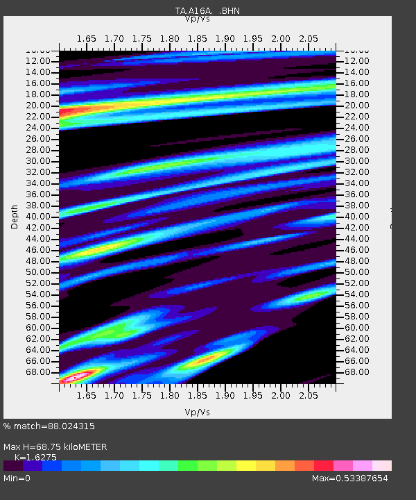
| Estimated Moho Depth: |
68.75 km |
| Estimated Crust Vp/Vs: |
1.63 |
| Assumed Crust Vp: |
6.242 km/s |
| Estimated Crust Vs: |
3.835 km/s |
| Estimated Crust Poisson's Ratio: |
0.20 |
|
| Radial Match: |
88.024315 % |
| Radial Bump: |
400 |
| Transverse Match: |
63.107323 % |
| Transverse Bump: |
400 |
| SOD ConfigId: |
2504 |
| Insert Time: |
2010-03-06 09:50:52.549 +0000 |
| GWidth: |
2.5 |
| Max Bumps: |
400 |
| Tol: |
0.001 |
|
Signal To Noise
| Channel | StoN | STA | LTA |
| TA:A16A: :BHN:20080507T16:13:01.524011Z | 3.8581808 | 3.054674E-7 | 7.9173944E-8 |
| TA:A16A: :BHE:20080507T16:13:01.524011Z | 1.5883683 | 6.4760535E-8 | 4.0771734E-8 |
| TA:A16A: :BHZ:20080507T16:13:01.524011Z | 1.4859184 | 1.0090368E-7 | 6.7906605E-8 |
| Arrivals |
| Ps | 7.2 SECOND |
| PpPs | 28 SECOND |
| PsPs/PpSs | 35 SECOND |


