You are here: Home > Network List > TA - USArray Transportable Network (new EarthScope stations) Stations List
> Station A16A West Butte Ranch, Sweetgrass, MT, USA > Earthquake Result Viewer
A16A West Butte Ranch, Sweetgrass, MT, USA - Earthquake Result Viewer
| Earthquake location: |
Solomon Islands |
| Earthquake latitude/longitude: |
-10.5/161.3 |
| Earthquake time(UTC): |
2008/06/03 (155) 16:20:50 GMT |
| Earthquake Depth: |
84 km |
| Earthquake Magnitude: |
6.2 MB, 6.2 MW, 6.2 MW |
| Earthquake Catalog/Contributor: |
WHDF/NEIC |
|
| Network: |
TA USArray Transportable Network (new EarthScope stations) |
| Station: |
A16A West Butte Ranch, Sweetgrass, MT, USA |
| Lat/Lon: |
48.95 N/111.60 W |
| Elevation: |
1394 m |
|
| Distance: |
96.0 deg |
| Az: |
41.452 deg |
| Baz: |
260.948 deg |
| Ray Param: |
0.040587362 |
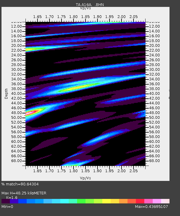
| Estimated Moho Depth: |
48.25 km |
| Estimated Crust Vp/Vs: |
1.60 |
| Assumed Crust Vp: |
6.242 km/s |
| Estimated Crust Vs: |
3.901 km/s |
| Estimated Crust Poisson's Ratio: |
0.18 |
|
| Radial Match: |
90.64304 % |
| Radial Bump: |
400 |
| Transverse Match: |
78.0762 % |
| Transverse Bump: |
400 |
| SOD ConfigId: |
2504 |
| Insert Time: |
2010-03-06 09:51:05.137 +0000 |
| GWidth: |
2.5 |
| Max Bumps: |
400 |
| Tol: |
0.001 |
|

Signal To Noise
| Channel | StoN | STA | LTA |
| TA:A16A: :BHN:20080603T16:33:36.598994Z | 15.7150755 | 8.668428E-7 | 5.515995E-8 |
| TA:A16A: :BHE:20080603T16:33:36.598994Z | 2.0358121 | 9.437129E-8 | 4.63556E-8 |
| TA:A16A: :BHZ:20080603T16:33:36.598994Z | 11.752772 | 3.6030886E-7 | 3.065735E-8 |
| Arrivals |
| Ps | 4.7 SECOND |
| PpPs | 20 SECOND |
| PsPs/PpSs | 24 SECOND |


