You are here: Home > Network List > TA - USArray Transportable Network (new EarthScope stations) Stations List
> Station E20K Nigu River, AK, USA > Earthquake Result Viewer
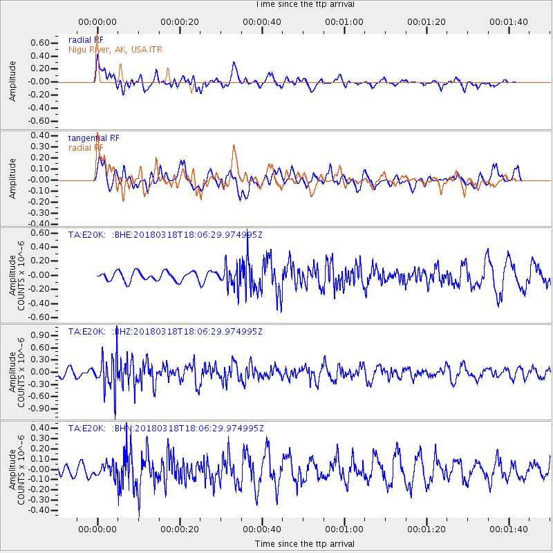
E20K Nigu River, AK, USA - Earthquake Result Viewer
*The percent match for this event was below the threshold and hence no stack was calculated.
| Earthquake location: |
Kuril Islands |
| Earthquake latitude/longitude: |
45.3/150.3 |
| Earthquake time(UTC): |
2018/03/18 (077) 18:00:10 GMT |
| Earthquake Depth: |
72 km |
| Earthquake Magnitude: |
5.1 Mww |
| Earthquake Catalog/Contributor: |
NEIC PDE/us |
|
| Network: |
TA USArray Transportable Network (new EarthScope stations) |
| Station: |
E20K Nigu River, AK, USA |
| Lat/Lon: |
68.26 N/156.19 W |
| Elevation: |
866 m |
|
| Distance: |
35.5 deg |
| Az: |
31.051 deg |
| Baz: |
257.56 deg |
| Ray Param: |
$rayparam |
*The percent match for this event was below the threshold and hence was not used in the summary stack. |
|
| Radial Match: |
57.028893 % |
| Radial Bump: |
400 |
| Transverse Match: |
73.07338 % |
| Transverse Bump: |
400 |
| SOD ConfigId: |
13570011 |
| Insert Time: |
2019-04-29 23:38:34.375 +0000 |
| GWidth: |
2.5 |
| Max Bumps: |
400 |
| Tol: |
0.001 |
|
Signal To Noise
| Channel | StoN | STA | LTA |
| TA:E20K: :BHZ:20180318T18:06:29.974995Z | 3.162212 | 4.0487066E-7 | 1.28034E-7 |
| TA:E20K: :BHN:20180318T18:06:29.974995Z | 1.0502229 | 5.909421E-8 | 5.6268256E-8 |
| TA:E20K: :BHE:20180318T18:06:29.974995Z | 2.2582638 | 1.4486031E-7 | 6.414676E-8 |
| Arrivals |
| Ps | |
| PpPs | |
| PsPs/PpSs | |


