You are here: Home > Network List > UW - Pacific Northwest Regional Seismic Network Stations List
> Station UMAT Pilot Rock, OR, USA > Earthquake Result Viewer
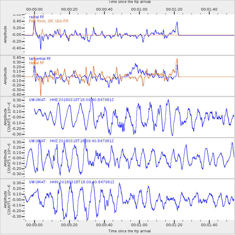
UMAT Pilot Rock, OR, USA - Earthquake Result Viewer
*The percent match for this event was below the threshold and hence no stack was calculated.
| Earthquake location: |
Kuril Islands |
| Earthquake latitude/longitude: |
45.3/150.3 |
| Earthquake time(UTC): |
2018/03/18 (077) 18:00:10 GMT |
| Earthquake Depth: |
72 km |
| Earthquake Magnitude: |
5.1 Mww |
| Earthquake Catalog/Contributor: |
NEIC PDE/us |
|
| Network: |
UW Pacific Northwest Regional Seismic Network |
| Station: |
UMAT Pilot Rock, OR, USA |
| Lat/Lon: |
45.29 N/118.96 W |
| Elevation: |
1318 m |
|
| Distance: |
60.3 deg |
| Az: |
54.356 deg |
| Baz: |
305.702 deg |
| Ray Param: |
$rayparam |
*The percent match for this event was below the threshold and hence was not used in the summary stack. |
|
| Radial Match: |
56.134235 % |
| Radial Bump: |
400 |
| Transverse Match: |
41.974747 % |
| Transverse Bump: |
400 |
| SOD ConfigId: |
13570011 |
| Insert Time: |
2019-04-29 23:40:15.409 +0000 |
| GWidth: |
2.5 |
| Max Bumps: |
400 |
| Tol: |
0.001 |
|
Signal To Noise
| Channel | StoN | STA | LTA |
| UW:UMAT: :HHZ:20180318T18:09:40.847981Z | 1.7247194 | 2.0735455E-7 | 1.2022508E-7 |
| UW:UMAT: :HHN:20180318T18:09:40.847981Z | 1.3780788 | 1.1181635E-7 | 8.11393E-8 |
| UW:UMAT: :HHE:20180318T18:09:40.847981Z | 1.590481 | 1.8311336E-7 | 1.1513081E-7 |
| Arrivals |
| Ps | |
| PpPs | |
| PsPs/PpSs | |


