You are here: Home > Network List > CI - Caltech Regional Seismic Network Stations List
> Station JCS Julian Camp Stevens, California, USA > Earthquake Result Viewer
JCS Julian Camp Stevens, California, USA - Earthquake Result Viewer
| Earthquake location: |
Fiji Islands Region |
| Earthquake latitude/longitude: |
-17.6/-178.7 |
| Earthquake time(UTC): |
2000/01/13 (013) 20:07:14 GMT |
| Earthquake Depth: |
535 km |
| Earthquake Magnitude: |
5.4 MB, 6.2 MW, 6.2 MW |
| Earthquake Catalog/Contributor: |
WHDF/NEIC |
|
| Network: |
CI Caltech Regional Seismic Network |
| Station: |
JCS Julian Camp Stevens, California, USA |
| Lat/Lon: |
33.09 N/116.60 W |
| Elevation: |
1258 m |
|
| Distance: |
77.8 deg |
| Az: |
49.403 deg |
| Baz: |
239.609 deg |
| Ray Param: |
0.048410952 |
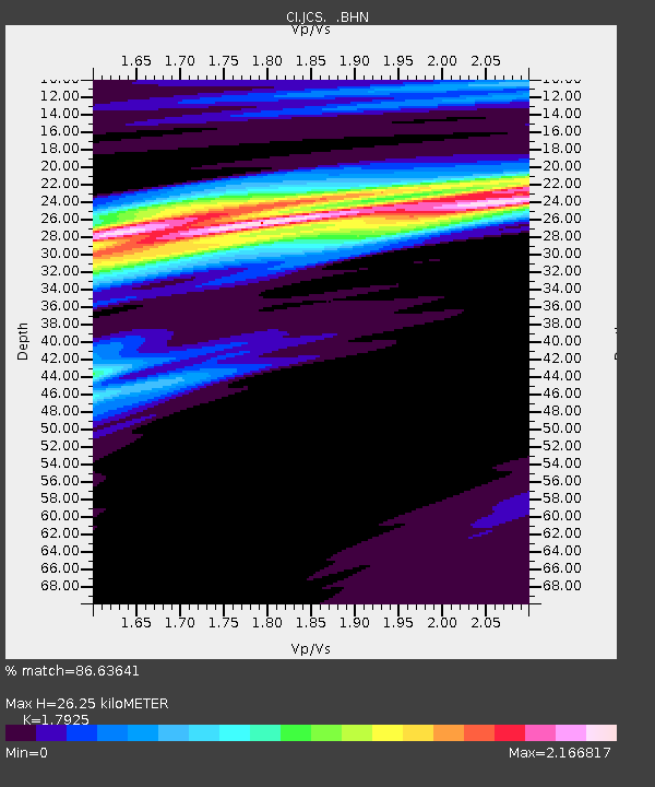
| Estimated Moho Depth: |
26.25 km |
| Estimated Crust Vp/Vs: |
1.79 |
| Assumed Crust Vp: |
6.264 km/s |
| Estimated Crust Vs: |
3.494 km/s |
| Estimated Crust Poisson's Ratio: |
0.27 |
|
| Radial Match: |
86.63641 % |
| Radial Bump: |
385 |
| Transverse Match: |
74.73635 % |
| Transverse Bump: |
400 |
| SOD ConfigId: |
3770 |
| Insert Time: |
2010-02-26 01:52:06.893 +0000 |
| GWidth: |
2.5 |
| Max Bumps: |
400 |
| Tol: |
0.001 |
|

Signal To Noise
| Channel | StoN | STA | LTA |
| CI:JCS: :BHN:20000113T20:17:45.557004Z | 0.8091043 | 4.0744112E-7 | 5.0357056E-7 |
| CI:JCS: :BHE:20000113T20:17:45.557004Z | 0.72841465 | 3.013126E-7 | 4.1365533E-7 |
| CI:JCS: :BHZ:20000113T20:17:45.557004Z | 1.013198 | 4.050598E-7 | 3.9978346E-7 |
| Arrivals |
| Ps | 3.4 SECOND |
| PpPs | 11 SECOND |
| PsPs/PpSs | 15 SECOND |


