You are here: Home > Network List > CI - Caltech Regional Seismic Network Stations List
> Station JCS Julian Camp Stevens, California, USA > Earthquake Result Viewer
JCS Julian Camp Stevens, California, USA - Earthquake Result Viewer
| Earthquake location: |
Tonga Islands |
| Earthquake latitude/longitude: |
-20.8/-174.2 |
| Earthquake time(UTC): |
2000/01/02 (002) 15:16:32 GMT |
| Earthquake Depth: |
33 km |
| Earthquake Magnitude: |
5.5 MB, 5.8 MS, 5.8 MW, 5.8 MW |
| Earthquake Catalog/Contributor: |
WHDF/NEIC |
|
| Network: |
CI Caltech Regional Seismic Network |
| Station: |
JCS Julian Camp Stevens, California, USA |
| Lat/Lon: |
33.09 N/116.60 W |
| Elevation: |
1258 m |
|
| Distance: |
76.8 deg |
| Az: |
46.761 deg |
| Baz: |
234.295 deg |
| Ray Param: |
0.050728 |
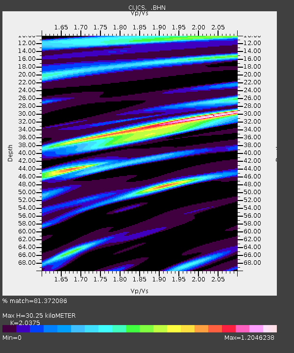
| Estimated Moho Depth: |
30.25 km |
| Estimated Crust Vp/Vs: |
2.04 |
| Assumed Crust Vp: |
6.264 km/s |
| Estimated Crust Vs: |
3.074 km/s |
| Estimated Crust Poisson's Ratio: |
0.34 |
|
| Radial Match: |
81.372086 % |
| Radial Bump: |
400 |
| Transverse Match: |
71.3419 % |
| Transverse Bump: |
400 |
| SOD ConfigId: |
3770 |
| Insert Time: |
2010-02-26 01:52:09.359 +0000 |
| GWidth: |
2.5 |
| Max Bumps: |
400 |
| Tol: |
0.001 |
|

Signal To Noise
| Channel | StoN | STA | LTA |
| CI:JCS: :BHN:20000102T15:27:49.407014Z | 0.68210167 | 1.4530715E-7 | 2.130286E-7 |
| CI:JCS: :BHE:20000102T15:27:49.407014Z | 1.097234 | 1.9048454E-7 | 1.7360432E-7 |
| CI:JCS: :BHZ:20000102T15:27:49.407014Z | 1.966265 | 4.2210763E-7 | 2.1467486E-7 |
| Arrivals |
| Ps | 5.1 SECOND |
| PpPs | 14 SECOND |
| PsPs/PpSs | 19 SECOND |


