You are here: Home > Network List > UW - Pacific Northwest Regional Seismic Network Stations List
> Station HOOD Mt Hood Meadows, OR CREST BB SMO > Earthquake Result Viewer
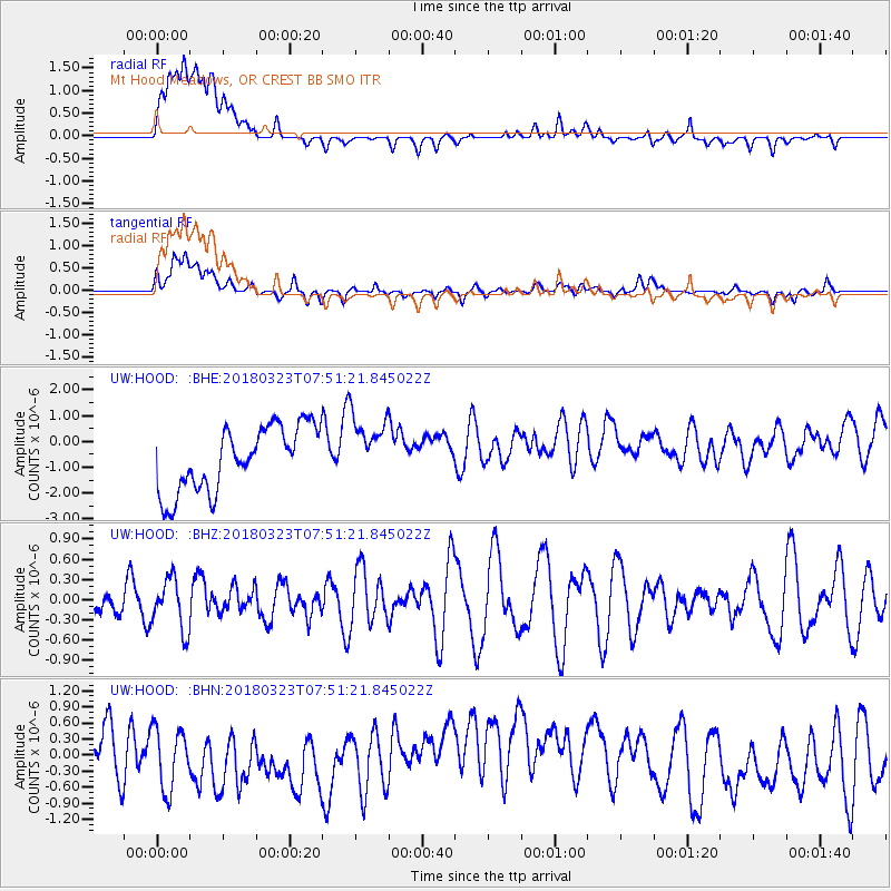
HOOD Mt Hood Meadows, OR CREST BB SMO - Earthquake Result Viewer
*The percent match for this event was below the threshold and hence no stack was calculated.
| Earthquake location: |
Northern Mid-Atlantic Ridge |
| Earthquake latitude/longitude: |
12.7/-44.6 |
| Earthquake time(UTC): |
2018/03/23 (082) 07:40:29 GMT |
| Earthquake Depth: |
10 km |
| Earthquake Magnitude: |
5.5 Mwb |
| Earthquake Catalog/Contributor: |
NEIC PDE/us |
|
| Network: |
UW Pacific Northwest Regional Seismic Network |
| Station: |
HOOD Mt Hood Meadows, OR CREST BB SMO |
| Lat/Lon: |
45.32 N/121.65 W |
| Elevation: |
1520 m |
|
| Distance: |
72.1 deg |
| Az: |
313.711 deg |
| Baz: |
90.064 deg |
| Ray Param: |
$rayparam |
*The percent match for this event was below the threshold and hence was not used in the summary stack. |
|
| Radial Match: |
38.92056 % |
| Radial Bump: |
400 |
| Transverse Match: |
43.720154 % |
| Transverse Bump: |
400 |
| SOD ConfigId: |
13570011 |
| Insert Time: |
2019-04-29 23:49:24.447 +0000 |
| GWidth: |
2.5 |
| Max Bumps: |
400 |
| Tol: |
0.001 |
|
Signal To Noise
| Channel | StoN | STA | LTA |
| UW:HOOD: :BHZ:20180323T07:51:21.845022Z | 1.1724398 | 3.8180772E-7 | 3.256523E-7 |
| UW:HOOD: :BHN:20180323T07:51:21.845022Z | 1.1811887 | 6.6717877E-7 | 5.648368E-7 |
| UW:HOOD: :BHE:20180323T07:51:21.845022Z | 0.99518234 | 1.241592E-6 | 1.2476027E-6 |
| Arrivals |
| Ps | |
| PpPs | |
| PsPs/PpSs | |


