You are here: Home > Network List > US - United States National Seismic Network Stations List
> Station LONY Lake Ozonia, New York, USA > Earthquake Result Viewer
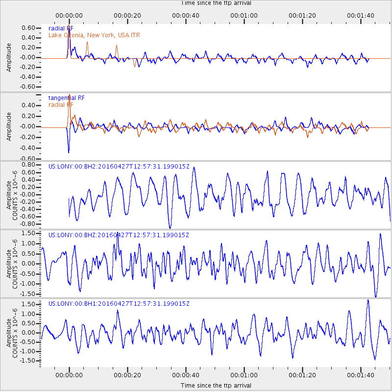
LONY Lake Ozonia, New York, USA - Earthquake Result Viewer
*The percent match for this event was below the threshold and hence no stack was calculated.
| Earthquake location: |
Near Coast Of Chiapas, Mexico |
| Earthquake latitude/longitude: |
14.6/-93.0 |
| Earthquake time(UTC): |
2016/04/27 (118) 12:51:22 GMT |
| Earthquake Depth: |
35 km |
| Earthquake Magnitude: |
5.8 MB |
| Earthquake Catalog/Contributor: |
NEIC PDE/NEIC COMCAT |
|
| Network: |
US United States National Seismic Network |
| Station: |
LONY Lake Ozonia, New York, USA |
| Lat/Lon: |
44.62 N/74.58 W |
| Elevation: |
440 m |
|
| Distance: |
33.8 deg |
| Az: |
23.897 deg |
| Baz: |
213.314 deg |
| Ray Param: |
$rayparam |
*The percent match for this event was below the threshold and hence was not used in the summary stack. |
|
| Radial Match: |
65.095795 % |
| Radial Bump: |
384 |
| Transverse Match: |
49.57639 % |
| Transverse Bump: |
400 |
| SOD ConfigId: |
1475611 |
| Insert Time: |
2016-05-11 12:56:12.840 +0000 |
| GWidth: |
2.5 |
| Max Bumps: |
400 |
| Tol: |
0.001 |
|
Signal To Noise
| Channel | StoN | STA | LTA |
| US:LONY:00:BHZ:20160427T12:57:31.199015Z | 1.9261514 | 7.5091396E-7 | 3.8985198E-7 |
| US:LONY:00:BH1:20160427T12:57:31.199015Z | 1.1734194 | 5.6290156E-7 | 4.797105E-7 |
| US:LONY:00:BH2:20160427T12:57:31.199015Z | 1.2536367 | 4.0219157E-7 | 3.2081988E-7 |
| Arrivals |
| Ps | |
| PpPs | |
| PsPs/PpSs | |


