You are here: Home > Network List > US - United States National Seismic Network Stations List
> Station MSO Missoula, Montana, USA > Earthquake Result Viewer
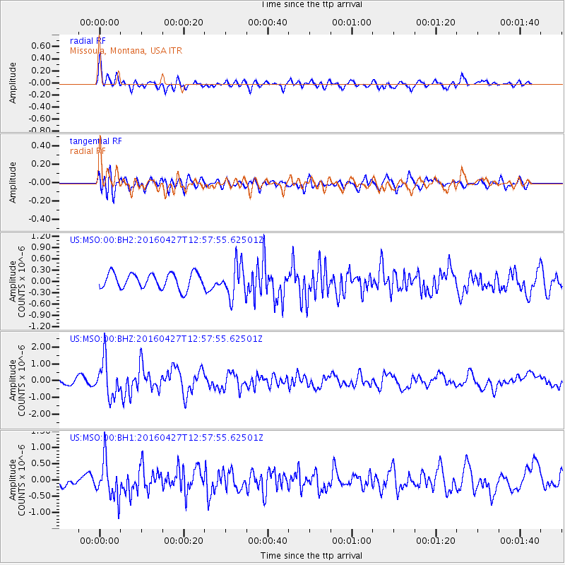
MSO Missoula, Montana, USA - Earthquake Result Viewer
*The percent match for this event was below the threshold and hence no stack was calculated.
| Earthquake location: |
Near Coast Of Chiapas, Mexico |
| Earthquake latitude/longitude: |
14.6/-93.0 |
| Earthquake time(UTC): |
2016/04/27 (118) 12:51:22 GMT |
| Earthquake Depth: |
35 km |
| Earthquake Magnitude: |
5.8 MB |
| Earthquake Catalog/Contributor: |
NEIC PDE/NEIC COMCAT |
|
| Network: |
US United States National Seismic Network |
| Station: |
MSO Missoula, Montana, USA |
| Lat/Lon: |
46.83 N/113.94 W |
| Elevation: |
1264 m |
|
| Distance: |
36.6 deg |
| Az: |
335.673 deg |
| Baz: |
144.486 deg |
| Ray Param: |
$rayparam |
*The percent match for this event was below the threshold and hence was not used in the summary stack. |
|
| Radial Match: |
68.048004 % |
| Radial Bump: |
400 |
| Transverse Match: |
55.755146 % |
| Transverse Bump: |
400 |
| SOD ConfigId: |
1475611 |
| Insert Time: |
2016-05-11 12:56:21.866 +0000 |
| GWidth: |
2.5 |
| Max Bumps: |
400 |
| Tol: |
0.001 |
|
Signal To Noise
| Channel | StoN | STA | LTA |
| US:MSO:00:BHZ:20160427T12:57:55.62501Z | 6.1567416 | 1.1185139E-6 | 1.8167303E-7 |
| US:MSO:00:BH1:20160427T12:57:55.62501Z | 2.896064 | 5.9231303E-7 | 2.0452346E-7 |
| US:MSO:00:BH2:20160427T12:57:55.62501Z | 2.1926856 | 4.4692453E-7 | 2.0382517E-7 |
| Arrivals |
| Ps | |
| PpPs | |
| PsPs/PpSs | |


