You are here: Home > Network List > CI - Caltech Regional Seismic Network Stations List
> Station JCS Julian Camp Stevens, California, USA > Earthquake Result Viewer
JCS Julian Camp Stevens, California, USA - Earthquake Result Viewer

| Earthquake location: |
Tonga Islands |
| Earthquake latitude/longitude: |
-17.3/-174.0 |
| Earthquake time(UTC): |
2000/01/26 (026) 13:26:50 GMT |
| Earthquake Depth: |
33 km |
| Earthquake Magnitude: |
5.9 MB, 6.0 MS, 6.4 MW, 6.3 MW |
| Earthquake Catalog/Contributor: |
WHDF/NEIC |
|
| Network: |
CI Caltech Regional Seismic Network |
| Station: |
JCS Julian Camp Stevens, California, USA |
| Lat/Lon: |
33.09 N/116.60 W |
| Elevation: |
1258 m |
|
| Distance: |
74.2 deg |
| Az: |
47.305 deg |
| Baz: |
236.77 deg |
| Ray Param: |
0.052424766 |
| Estimated Moho Depth: |
32.75 km |
| Estimated Crust Vp/Vs: |
1.87 |
| Assumed Crust Vp: |
6.264 km/s |
| Estimated Crust Vs: |
3.359 km/s |
| Estimated Crust Poisson's Ratio: |
0.30 |
|
| Radial Match: |
87.486664 % |
| Radial Bump: |
357 |
| Transverse Match: |
63.715836 % |
| Transverse Bump: |
400 |
| SOD ConfigId: |
3744 |
| Insert Time: |
2010-02-26 01:52:10.462 +0000 |
| GWidth: |
2.5 |
| Max Bumps: |
400 |
| Tol: |
0.001 |
|
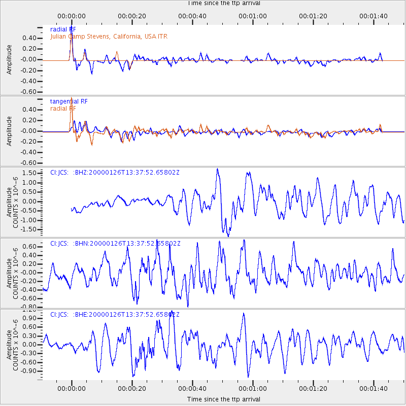
Signal To Noise
| Channel | StoN | STA | LTA |
| CI:JCS: :BHN:20000126T13:37:52.65802Z | 0.8335793 | 2.2386479E-7 | 2.6855847E-7 |
| CI:JCS: :BHE:20000126T13:37:52.65802Z | 0.43807042 | 9.9370865E-8 | 2.2683766E-7 |
| CI:JCS: :BHZ:20000126T13:37:52.65802Z | 1.3524226 | 3.011348E-7 | 2.2266325E-7 |
| Arrivals |
| Ps | 4.7 SECOND |
| PpPs | 15 SECOND |
| PsPs/PpSs | 19 SECOND |


