You are here: Home > Network List > CI - Caltech Regional Seismic Network Stations List
> Station JCS Julian Camp Stevens, California, USA > Earthquake Result Viewer
JCS Julian Camp Stevens, California, USA - Earthquake Result Viewer
| Earthquake location: |
Fiji Islands Region |
| Earthquake latitude/longitude: |
-18.8/174.4 |
| Earthquake time(UTC): |
2000/01/09 (009) 21:54:40 GMT |
| Earthquake Depth: |
33 km |
| Earthquake Magnitude: |
5.6 MB, 6.4 MS, 6.4 MW, 6.3 MW |
| Earthquake Catalog/Contributor: |
WHDF/NEIC |
|
| Network: |
CI Caltech Regional Seismic Network |
| Station: |
JCS Julian Camp Stevens, California, USA |
| Lat/Lon: |
33.09 N/116.60 W |
| Elevation: |
1258 m |
|
| Distance: |
83.7 deg |
| Az: |
52.069 deg |
| Baz: |
242.86 deg |
| Ray Param: |
0.04597973 |
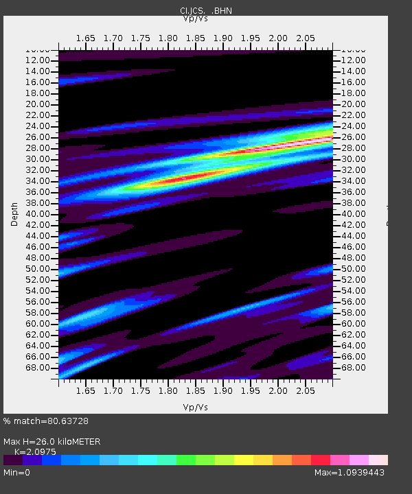
| Estimated Moho Depth: |
26.0 km |
| Estimated Crust Vp/Vs: |
2.10 |
| Assumed Crust Vp: |
6.264 km/s |
| Estimated Crust Vs: |
2.986 km/s |
| Estimated Crust Poisson's Ratio: |
0.35 |
|
| Radial Match: |
80.63728 % |
| Radial Bump: |
395 |
| Transverse Match: |
63.335297 % |
| Transverse Bump: |
400 |
| SOD ConfigId: |
3744 |
| Insert Time: |
2010-02-26 01:52:12.299 +0000 |
| GWidth: |
2.5 |
| Max Bumps: |
400 |
| Tol: |
0.001 |
|

Signal To Noise
| Channel | StoN | STA | LTA |
| CI:JCS: :BHN:20000109T22:06:34.656016Z | 1.1190636 | 2.1795486E-7 | 1.9476539E-7 |
| CI:JCS: :BHE:20000109T22:06:34.656016Z | 1.3893294 | 2.9785525E-7 | 2.1438778E-7 |
| CI:JCS: :BHZ:20000109T22:06:34.656016Z | 1.1495942 | 4.3540788E-7 | 3.787492E-7 |
| Arrivals |
| Ps | 4.6 SECOND |
| PpPs | 13 SECOND |
| PsPs/PpSs | 17 SECOND |


