You are here: Home > Network List > CN - Canadian National Seismograph Network Stations List
> Station INK INUVIK, NT > Earthquake Result Viewer
INK INUVIK, NT - Earthquake Result Viewer
*The percent match for this event was below the threshold and hence no stack was calculated.
| Earthquake location: |
New Britain Region, P.N.G. |
| Earthquake latitude/longitude: |
-5.5/151.5 |
| Earthquake time(UTC): |
2018/03/24 (083) 11:23:32 GMT |
| Earthquake Depth: |
36 km |
| Earthquake Magnitude: |
6.3 mww |
| Earthquake Catalog/Contributor: |
NEIC PDE/us |
|
| Network: |
CN Canadian National Seismograph Network |
| Station: |
INK INUVIK, NT |
| Lat/Lon: |
68.31 N/133.53 W |
| Elevation: |
44 m |
|
| Distance: |
89.6 deg |
| Az: |
21.046 deg |
| Baz: |
254.063 deg |
| Ray Param: |
$rayparam |
*The percent match for this event was below the threshold and hence was not used in the summary stack. |
|
| Radial Match: |
58.443314 % |
| Radial Bump: |
400 |
| Transverse Match: |
54.22872 % |
| Transverse Bump: |
400 |
| SOD ConfigId: |
13570011 |
| Insert Time: |
2019-04-29 23:56:47.797 +0000 |
| GWidth: |
2.5 |
| Max Bumps: |
400 |
| Tol: |
0.001 |
|
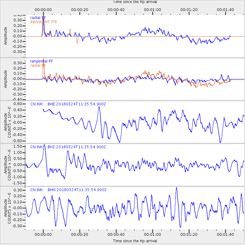
Signal To Noise
| Channel | StoN | STA | LTA |
| CN:INK: :BHZ:20180324T11:35:54.900Z | 8.162412 | 8.610843E-7 | 1.0549385E-7 |
| CN:INK: :BHN:20180324T11:35:54.900Z | 1.1737626 | 1.2046806E-7 | 1.026341E-7 |
| CN:INK: :BHE:20180324T11:35:54.900Z | 1.9794542 | 3.2951095E-7 | 1.6646557E-7 |
| Arrivals |
| Ps | |
| PpPs | |
| PsPs/PpSs | |


