You are here: Home > Network List > TA - USArray Transportable Network (new EarthScope stations) Stations List
> Station A16A West Butte Ranch, Sweetgrass, MT, USA > Earthquake Result Viewer
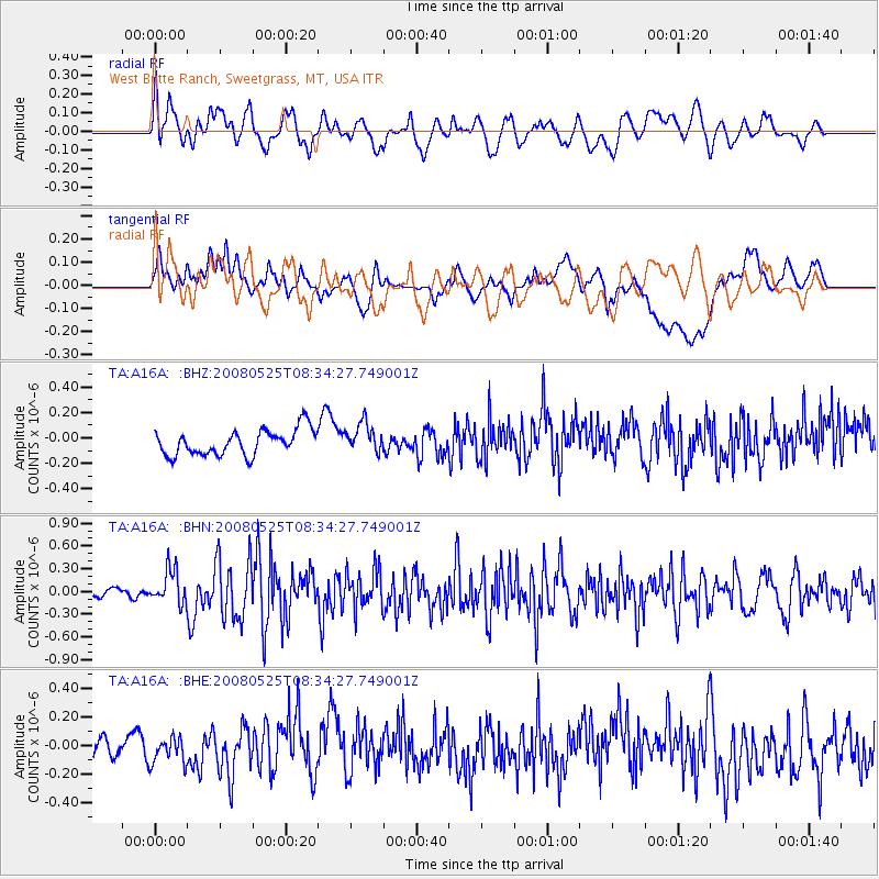
A16A West Butte Ranch, Sweetgrass, MT, USA - Earthquake Result Viewer
*The percent match for this event was below the threshold and hence no stack was calculated.
| Earthquake location: |
Sichuan, China |
| Earthquake latitude/longitude: |
32.6/105.4 |
| Earthquake time(UTC): |
2008/05/25 (146) 08:21:48 GMT |
| Earthquake Depth: |
10 km |
| Earthquake Magnitude: |
5.8 MB, 6.0 MS, 6.0 MW, 6.0 MW |
| Earthquake Catalog/Contributor: |
WHDF/NEIC |
|
| Network: |
TA USArray Transportable Network (new EarthScope stations) |
| Station: |
A16A West Butte Ranch, Sweetgrass, MT, USA |
| Lat/Lon: |
48.95 N/111.60 W |
| Elevation: |
1394 m |
|
| Distance: |
92.4 deg |
| Az: |
23.408 deg |
| Baz: |
329.413 deg |
| Ray Param: |
$rayparam |
*The percent match for this event was below the threshold and hence was not used in the summary stack. |
|
| Radial Match: |
67.90964 % |
| Radial Bump: |
400 |
| Transverse Match: |
43.290855 % |
| Transverse Bump: |
400 |
| SOD ConfigId: |
2504 |
| Insert Time: |
2010-03-06 09:53:36.798 +0000 |
| GWidth: |
2.5 |
| Max Bumps: |
400 |
| Tol: |
0.001 |
|
Signal To Noise
| Channel | StoN | STA | LTA |
| TA:A16A: :BHN:20080525T08:34:27.749001Z | 3.3181255 | 2.2558417E-7 | 6.7985425E-8 |
| TA:A16A: :BHE:20080525T08:34:27.749001Z | 0.9199452 | 8.99505E-8 | 9.7778106E-8 |
| TA:A16A: :BHZ:20080525T08:34:27.749001Z | 1.1582576 | 1.156056E-7 | 9.9809924E-8 |
| Arrivals |
| Ps | |
| PpPs | |
| PsPs/PpSs | |


