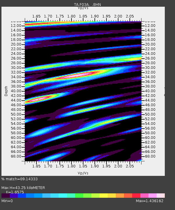
F03A Seaside, OR, USA - Earthquake Result Viewer
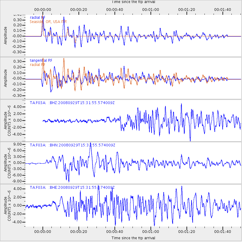
Earthquake location: Kermadec Islands, New Zealand
Earthquake latitude/longitude: -29.8/-177.7
Earthquake time(UTC): 2008/09/29 (273) 15:19:31 GMT
Earthquake Depth: 36 km
Earthquake Magnitude: 6.5 MB, 6.7 MS, 7.0 MW, 7.0 MW
Earthquake Catalog/Contributor: WHDF/NEIC
Network: TA USArray Transportable Network (new EarthScope stations)
Station: F03A Seaside, OR, USA
Lat/Lon: 45.93 N/123.56 W
Elevation: 325 m
Distance: 89.9 deg
Az: 34.439 deg
Baz: 224.798 deg
Ray Param: 0.04170835
Estimated Moho Depth: 43.25 km
Estimated Crust Vp/Vs: 1.66
Assumed Crust Vp: 6.566 km/s
Estimated Crust Vs: 3.961 km/s
Estimated Crust Poisson's Ratio: 0.21
Radial Match: 89.14333 %
Radial Bump: 400
Transverse Match: 88.959694 %
Transverse Bump: 400
SOD ConfigId: 2560
Insert Time: 2010-03-06 09:54:07.892 +0000
GWidth: 2.5
Max Bumps: 400
Tol: 0.001

Signal To Noise

ChannelStoNSTALTA
TA:F03A: :BHN:20080929T15:31:55.574009Z4.62539537.185342E-71.5534546E-7
TA:F03A: :BHE:20080929T15:31:55.574009Z0.906269971.9501087E-72.1517967E-7
TA:F03A: :BHZ:20080929T15:31:55.574009Z1.14435342.4037408E-72.1005232E-7
Arrivals
Ps4.4 SECOND
PpPs17 SECOND
PsPs/PpSs22 SECOND