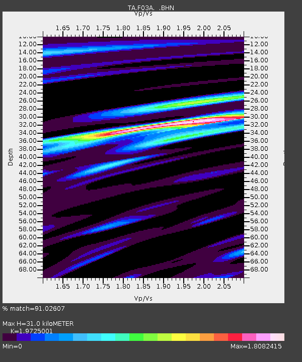
F03A Seaside, OR, USA - Earthquake Result Viewer
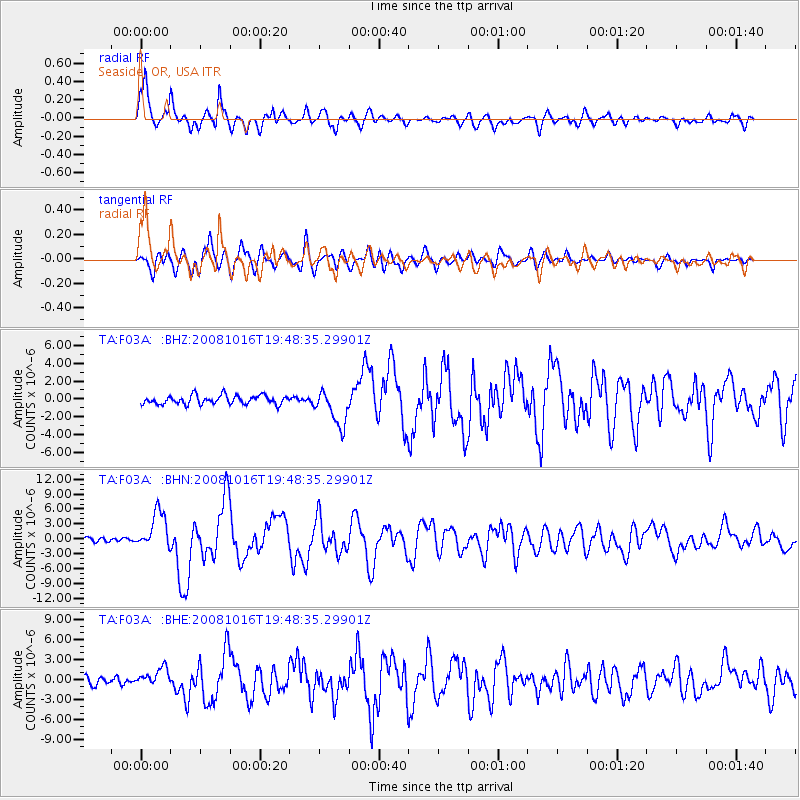
Earthquake location: Near Coast Of Chiapas, Mexico
Earthquake latitude/longitude: 14.4/-92.4
Earthquake time(UTC): 2008/10/16 (290) 19:41:25 GMT
Earthquake Depth: 24 km
Earthquake Magnitude: 6.1 MB, 6.6 MS, 6.7 MW, 6.6 MW
Earthquake Catalog/Contributor: WHDF/NEIC
Network: TA USArray Transportable Network (new EarthScope stations)
Station: F03A Seaside, OR, USA
Lat/Lon: 45.93 N/123.56 W
Elevation: 325 m
Distance: 40.9 deg
Az: 326.497 deg
Baz: 129.98 deg
Ray Param: 0.07408001
Estimated Moho Depth: 31.0 km
Estimated Crust Vp/Vs: 1.97
Assumed Crust Vp: 6.566 km/s
Estimated Crust Vs: 3.329 km/s
Estimated Crust Poisson's Ratio: 0.33
Radial Match: 91.02607 %
Radial Bump: 400
Transverse Match: 75.06976 %
Transverse Bump: 400
SOD ConfigId: 2560
Insert Time: 2010-03-06 09:54:10.124 +0000
GWidth: 2.5
Max Bumps: 400
Tol: 0.001

Signal To Noise

ChannelStoNSTALTA
TA:F03A: :BHN:20081016T19:48:35.29901Z9.9170693.7982081E-63.8299703E-7
TA:F03A: :BHE:20081016T19:48:35.29901Z2.52424881.341757E-65.31547E-7
TA:F03A: :BHZ:20081016T19:48:35.29901Z4.14082672.0225727E-64.8844663E-7
Arrivals
Ps4.9 SECOND
PpPs13 SECOND
PsPs/PpSs18 SECOND