You are here: Home > Network List > TA - USArray Transportable Network (new EarthScope stations) Stations List
> Station D27M Malcolm River, YT, CAN > Earthquake Result Viewer
D27M Malcolm River, YT, CAN - Earthquake Result Viewer
| Earthquake location: |
New Britain Region, P.N.G. |
| Earthquake latitude/longitude: |
-5.5/151.5 |
| Earthquake time(UTC): |
2018/03/24 (083) 11:23:32 GMT |
| Earthquake Depth: |
36 km |
| Earthquake Magnitude: |
6.3 mww |
| Earthquake Catalog/Contributor: |
NEIC PDE/us |
|
| Network: |
TA USArray Transportable Network (new EarthScope stations) |
| Station: |
D27M Malcolm River, YT, CAN |
| Lat/Lon: |
69.24 N/140.96 W |
| Elevation: |
896 m |
|
| Distance: |
87.3 deg |
| Az: |
19.259 deg |
| Baz: |
247.084 deg |
| Ray Param: |
0.04336434 |
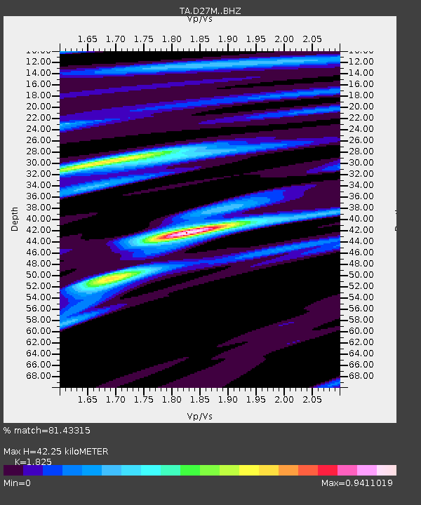
| Estimated Moho Depth: |
42.25 km |
| Estimated Crust Vp/Vs: |
1.83 |
| Assumed Crust Vp: |
6.522 km/s |
| Estimated Crust Vs: |
3.573 km/s |
| Estimated Crust Poisson's Ratio: |
0.29 |
|
| Radial Match: |
81.43315 % |
| Radial Bump: |
381 |
| Transverse Match: |
77.567406 % |
| Transverse Bump: |
400 |
| SOD ConfigId: |
13570011 |
| Insert Time: |
2019-04-29 23:59:29.931 +0000 |
| GWidth: |
2.5 |
| Max Bumps: |
400 |
| Tol: |
0.001 |
|

Signal To Noise
| Channel | StoN | STA | LTA |
| TA:D27M: :BHZ:20180324T11:35:44.324988Z | 12.399966 | 1.3645683E-6 | 1.1004614E-7 |
| TA:D27M: :BHN:20180324T11:35:44.324988Z | 1.341596 | 1.109377E-7 | 8.269084E-8 |
| TA:D27M: :BHE:20180324T11:35:44.324988Z | 4.6852107 | 3.2175817E-7 | 6.867528E-8 |
| Arrivals |
| Ps | 5.5 SECOND |
| PpPs | 18 SECOND |
| PsPs/PpSs | 23 SECOND |


