You are here: Home > Network List > TA - USArray Transportable Network (new EarthScope stations) Stations List
> Station E18K Tukpahlearik Creek, AK, USA > Earthquake Result Viewer
E18K Tukpahlearik Creek, AK, USA - Earthquake Result Viewer

| Earthquake location: |
New Britain Region, P.N.G. |
| Earthquake latitude/longitude: |
-5.5/151.5 |
| Earthquake time(UTC): |
2018/03/24 (083) 11:23:32 GMT |
| Earthquake Depth: |
36 km |
| Earthquake Magnitude: |
6.3 mww |
| Earthquake Catalog/Contributor: |
NEIC PDE/us |
|
| Network: |
TA USArray Transportable Network (new EarthScope stations) |
| Station: |
E18K Tukpahlearik Creek, AK, USA |
| Lat/Lon: |
67.42 N/160.60 W |
| Elevation: |
297 m |
|
| Distance: |
80.2 deg |
| Az: |
16.907 deg |
| Baz: |
228.567 deg |
| Ray Param: |
0.048383307 |
| Estimated Moho Depth: |
29.5 km |
| Estimated Crust Vp/Vs: |
1.67 |
| Assumed Crust Vp: |
6.276 km/s |
| Estimated Crust Vs: |
3.764 km/s |
| Estimated Crust Poisson's Ratio: |
0.22 |
|
| Radial Match: |
86.10631 % |
| Radial Bump: |
400 |
| Transverse Match: |
74.248695 % |
| Transverse Bump: |
400 |
| SOD ConfigId: |
13570011 |
| Insert Time: |
2019-04-29 23:59:32.131 +0000 |
| GWidth: |
2.5 |
| Max Bumps: |
400 |
| Tol: |
0.001 |
|
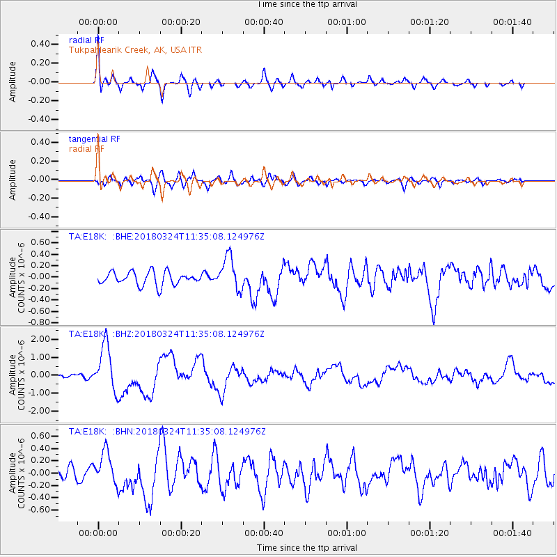
Signal To Noise
| Channel | StoN | STA | LTA |
| TA:E18K: :BHZ:20180324T11:35:08.124976Z | 11.613458 | 1.3487156E-6 | 1.1613385E-7 |
| TA:E18K: :BHN:20180324T11:35:08.124976Z | 3.005415 | 2.7929462E-7 | 9.293047E-8 |
| TA:E18K: :BHE:20180324T11:35:08.124976Z | 2.6553195 | 3.0501855E-7 | 1.1487075E-7 |
| Arrivals |
| Ps | 3.2 SECOND |
| PpPs | 12 SECOND |
| PsPs/PpSs | 15 SECOND |


