You are here: Home > Network List > TA - USArray Transportable Network (new EarthScope stations) Stations List
> Station F26K Sheenjek River, AK, USA > Earthquake Result Viewer
F26K Sheenjek River, AK, USA - Earthquake Result Viewer

| Earthquake location: |
New Britain Region, P.N.G. |
| Earthquake latitude/longitude: |
-5.5/151.5 |
| Earthquake time(UTC): |
2018/03/24 (083) 11:23:32 GMT |
| Earthquake Depth: |
36 km |
| Earthquake Magnitude: |
6.3 mww |
| Earthquake Catalog/Contributor: |
NEIC PDE/us |
|
| Network: |
TA USArray Transportable Network (new EarthScope stations) |
| Station: |
F26K Sheenjek River, AK, USA |
| Lat/Lon: |
67.69 N/144.15 W |
| Elevation: |
683 m |
|
| Distance: |
85.6 deg |
| Az: |
20.194 deg |
| Baz: |
244.185 deg |
| Ray Param: |
0.044595525 |
| Estimated Moho Depth: |
34.75 km |
| Estimated Crust Vp/Vs: |
1.68 |
| Assumed Crust Vp: |
6.522 km/s |
| Estimated Crust Vs: |
3.876 km/s |
| Estimated Crust Poisson's Ratio: |
0.23 |
|
| Radial Match: |
86.25515 % |
| Radial Bump: |
233 |
| Transverse Match: |
75.51843 % |
| Transverse Bump: |
315 |
| SOD ConfigId: |
13570011 |
| Insert Time: |
2019-04-29 23:59:45.050 +0000 |
| GWidth: |
2.5 |
| Max Bumps: |
400 |
| Tol: |
0.001 |
|
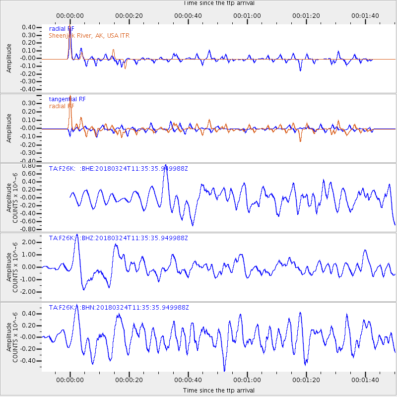
Signal To Noise
| Channel | StoN | STA | LTA |
| TA:F26K: :BHZ:20180324T11:35:35.949988Z | 11.427804 | 1.4256838E-6 | 1.2475572E-7 |
| TA:F26K: :BHN:20180324T11:35:35.949988Z | 2.6878169 | 2.88521E-7 | 1.0734399E-7 |
| TA:F26K: :BHE:20180324T11:35:35.949988Z | 3.230206 | 4.0836275E-7 | 1.2642003E-7 |
| Arrivals |
| Ps | 3.7 SECOND |
| PpPs | 14 SECOND |
| PsPs/PpSs | 18 SECOND |


