You are here: Home > Network List > TA - USArray Transportable Network (new EarthScope stations) Stations List
> Station F03A Seaside, OR, USA > Earthquake Result Viewer
F03A Seaside, OR, USA - Earthquake Result Viewer
| Earthquake location: |
Andreanof Islands, Aleutian Is. |
| Earthquake latitude/longitude: |
51.3/-179.5 |
| Earthquake time(UTC): |
2007/12/19 (353) 10:24:33 GMT |
| Earthquake Depth: |
30 km |
| Earthquake Magnitude: |
5.5 MB, 5.3 ML |
| Earthquake Catalog/Contributor: |
WHDF/NEIC |
|
| Network: |
TA USArray Transportable Network (new EarthScope stations) |
| Station: |
F03A Seaside, OR, USA |
| Lat/Lon: |
45.93 N/123.56 W |
| Elevation: |
325 m |
|
| Distance: |
36.6 deg |
| Az: |
75.952 deg |
| Baz: |
299.337 deg |
| Ray Param: |
0.07654875 |
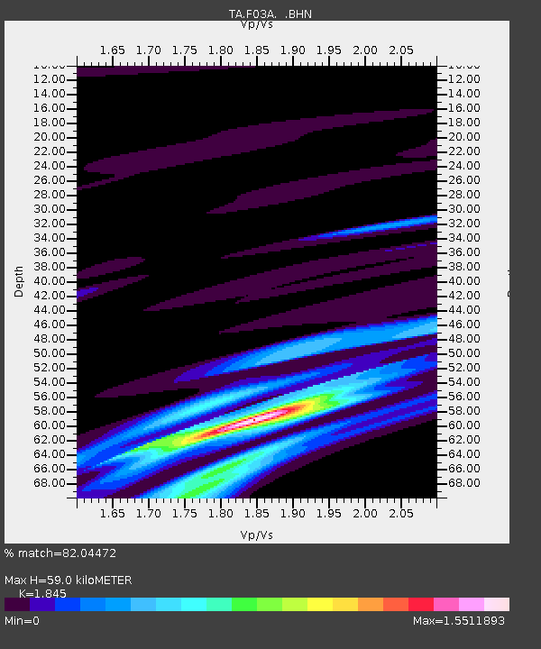
| Estimated Moho Depth: |
59.0 km |
| Estimated Crust Vp/Vs: |
1.85 |
| Assumed Crust Vp: |
6.566 km/s |
| Estimated Crust Vs: |
3.559 km/s |
| Estimated Crust Poisson's Ratio: |
0.29 |
|
| Radial Match: |
82.04472 % |
| Radial Bump: |
400 |
| Transverse Match: |
62.13657 % |
| Transverse Bump: |
400 |
| SOD ConfigId: |
2564 |
| Insert Time: |
2010-03-06 09:54:22.275 +0000 |
| GWidth: |
2.5 |
| Max Bumps: |
400 |
| Tol: |
0.001 |
|
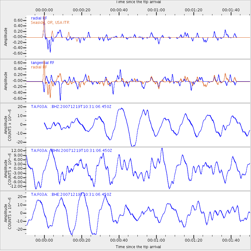
Signal To Noise
| Channel | StoN | STA | LTA |
| TA:F03A: :BHN:20071219T10:31:06.450Z | 1.3043611 | 7.761959E-6 | 5.9507743E-6 |
| TA:F03A: :BHE:20071219T10:31:06.450Z | 1.8853102 | 1.0922698E-5 | 5.7935813E-6 |
| TA:F03A: :BHZ:20071219T10:31:06.450Z | 2.4778686 | 9.08127E-6 | 3.6649524E-6 |
| Arrivals |
| Ps | 8.2 SECOND |
| PpPs | 24 SECOND |
| PsPs/PpSs | 32 SECOND |


