You are here: Home > Network List > TA - USArray Transportable Network (new EarthScope stations) Stations List
> Station F03A Seaside, OR, USA > Earthquake Result Viewer
F03A Seaside, OR, USA - Earthquake Result Viewer
| Earthquake location: |
South Of Fiji Islands |
| Earthquake latitude/longitude: |
-26.0/-177.5 |
| Earthquake time(UTC): |
2007/12/09 (343) 07:28:20 GMT |
| Earthquake Depth: |
152 km |
| Earthquake Magnitude: |
7.0 MB, 7.8 MW, 7.7 MW |
| Earthquake Catalog/Contributor: |
WHDF/NEIC |
|
| Network: |
TA USArray Transportable Network (new EarthScope stations) |
| Station: |
F03A Seaside, OR, USA |
| Lat/Lon: |
45.93 N/123.56 W |
| Elevation: |
325 m |
|
| Distance: |
86.7 deg |
| Az: |
34.42 deg |
| Baz: |
226.793 deg |
| Ray Param: |
0.043508515 |
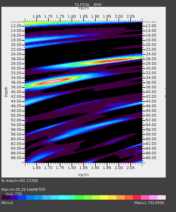
| Estimated Moho Depth: |
35.25 km |
| Estimated Crust Vp/Vs: |
1.73 |
| Assumed Crust Vp: |
6.566 km/s |
| Estimated Crust Vs: |
3.806 km/s |
| Estimated Crust Poisson's Ratio: |
0.25 |
|
| Radial Match: |
90.23359 % |
| Radial Bump: |
400 |
| Transverse Match: |
92.33251 % |
| Transverse Bump: |
372 |
| SOD ConfigId: |
2564 |
| Insert Time: |
2010-03-06 09:54:28.288 +0000 |
| GWidth: |
2.5 |
| Max Bumps: |
400 |
| Tol: |
0.001 |
|
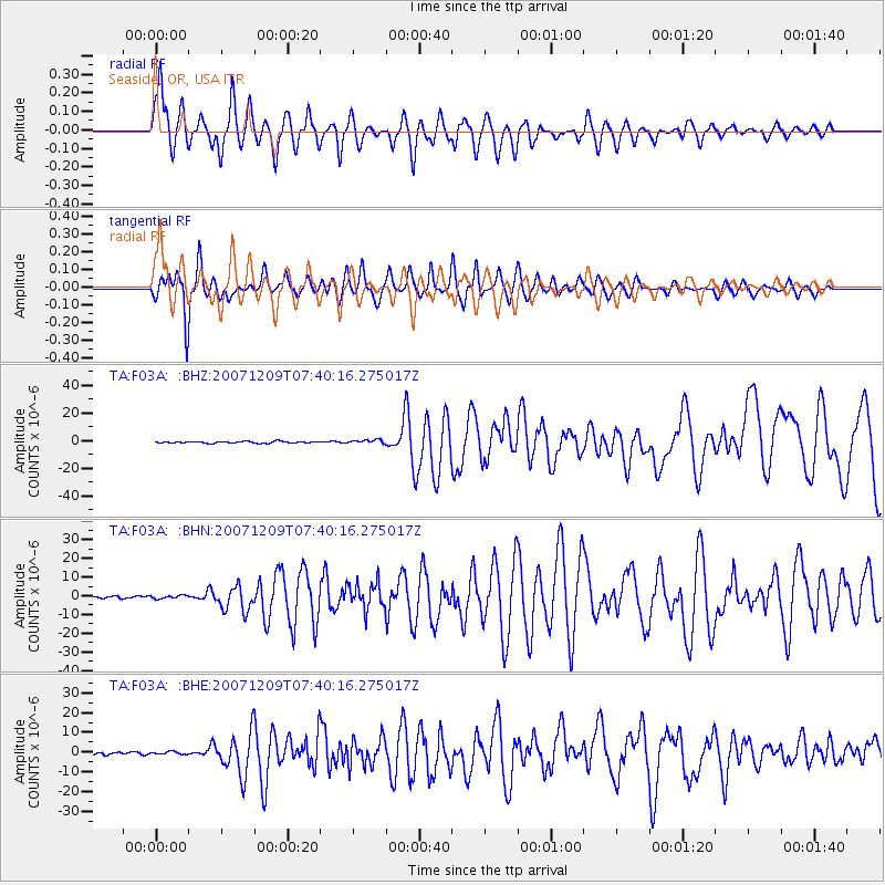
Signal To Noise
| Channel | StoN | STA | LTA |
| TA:F03A: :BHN:20071209T07:40:16.275017Z | 1.3647686 | 8.8793763E-7 | 6.50614E-7 |
| TA:F03A: :BHE:20071209T07:40:16.275017Z | 0.9945641 | 7.176083E-7 | 7.215305E-7 |
| TA:F03A: :BHZ:20071209T07:40:16.275017Z | 2.347099 | 1.3973523E-6 | 5.9535296E-7 |
| Arrivals |
| Ps | 4.0 SECOND |
| PpPs | 14 SECOND |
| PsPs/PpSs | 18 SECOND |


