You are here: Home > Network List > TA - USArray Transportable Network (new EarthScope stations) Stations List
> Station H27K Steamboat Mountain, AK, USA > Earthquake Result Viewer
H27K Steamboat Mountain, AK, USA - Earthquake Result Viewer
| Earthquake location: |
New Britain Region, P.N.G. |
| Earthquake latitude/longitude: |
-5.5/151.5 |
| Earthquake time(UTC): |
2018/03/24 (083) 11:23:32 GMT |
| Earthquake Depth: |
36 km |
| Earthquake Magnitude: |
6.3 mww |
| Earthquake Catalog/Contributor: |
NEIC PDE/us |
|
| Network: |
TA USArray Transportable Network (new EarthScope stations) |
| Station: |
H27K Steamboat Mountain, AK, USA |
| Lat/Lon: |
66.23 N/141.53 W |
| Elevation: |
786 m |
|
| Distance: |
85.9 deg |
| Az: |
21.964 deg |
| Baz: |
246.724 deg |
| Ray Param: |
0.04436301 |
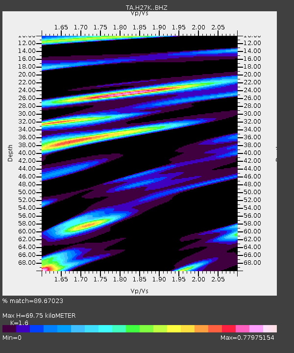
| Estimated Moho Depth: |
69.75 km |
| Estimated Crust Vp/Vs: |
1.60 |
| Assumed Crust Vp: |
6.577 km/s |
| Estimated Crust Vs: |
4.11 km/s |
| Estimated Crust Poisson's Ratio: |
0.18 |
|
| Radial Match: |
89.67023 % |
| Radial Bump: |
400 |
| Transverse Match: |
79.483894 % |
| Transverse Bump: |
400 |
| SOD ConfigId: |
13570011 |
| Insert Time: |
2019-04-30 00:00:18.137 +0000 |
| GWidth: |
2.5 |
| Max Bumps: |
400 |
| Tol: |
0.001 |
|

Signal To Noise
| Channel | StoN | STA | LTA |
| TA:H27K: :BHZ:20180324T11:35:37.574988Z | 13.552108 | 1.3291346E-6 | 9.8075866E-8 |
| TA:H27K: :BHN:20180324T11:35:37.574988Z | 2.5413122 | 2.8789196E-7 | 1.1328477E-7 |
| TA:H27K: :BHE:20180324T11:35:37.574988Z | 7.240578 | 4.5426327E-7 | 6.2738536E-8 |
| Arrivals |
| Ps | 6.5 SECOND |
| PpPs | 27 SECOND |
| PsPs/PpSs | 33 SECOND |


