You are here: Home > Network List > TA - USArray Transportable Network (new EarthScope stations) Stations List
> Station J18K Innoko River, AK, USA > Earthquake Result Viewer
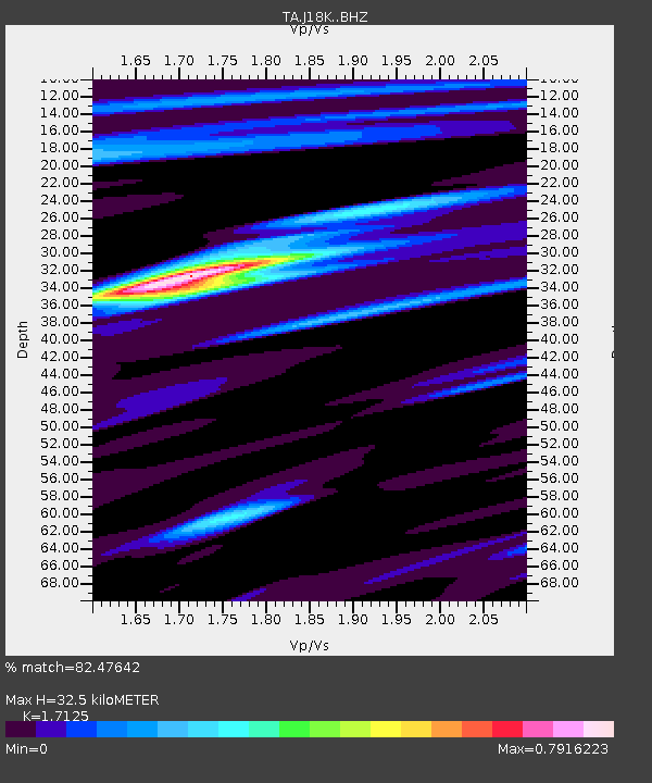
J18K Innoko River, AK, USA - Earthquake Result Viewer
| Earthquake location: |
New Britain Region, P.N.G. |
| Earthquake latitude/longitude: |
-5.5/151.5 |
| Earthquake time(UTC): |
2018/03/24 (083) 11:23:32 GMT |
| Earthquake Depth: |
36 km |
| Earthquake Magnitude: |
6.3 mww |
| Earthquake Catalog/Contributor: |
NEIC PDE/us |
|
| Network: |
TA USArray Transportable Network (new EarthScope stations) |
| Station: |
J18K Innoko River, AK, USA |
| Lat/Lon: |
63.47 N/156.72 W |
| Elevation: |
506 m |
|
| Distance: |
78.9 deg |
| Az: |
21.079 deg |
| Baz: |
232.856 deg |
| Ray Param: |
0.04924385 |
| Estimated Moho Depth: |
32.5 km |
| Estimated Crust Vp/Vs: |
1.71 |
| Assumed Crust Vp: |
6.182 km/s |
| Estimated Crust Vs: |
3.61 km/s |
| Estimated Crust Poisson's Ratio: |
0.24 |
|
| Radial Match: |
82.47642 % |
| Radial Bump: |
277 |
| Transverse Match: |
52.471848 % |
| Transverse Bump: |
400 |
| SOD ConfigId: |
13570011 |
| Insert Time: |
2019-04-30 00:00:28.126 +0000 |
| GWidth: |
2.5 |
| Max Bumps: |
400 |
| Tol: |
0.001 |
|

Signal To Noise
| Channel | StoN | STA | LTA |
| TA:J18K: :BHZ:20180324T11:35:01.300024Z | 7.139707 | 1.2685488E-6 | 1.7767518E-7 |
| TA:J18K: :BHN:20180324T11:35:01.300024Z | 2.3342662 | 3.916931E-7 | 1.6780139E-7 |
| TA:J18K: :BHE:20180324T11:35:01.300024Z | 2.0374455 | 3.9957135E-7 | 1.9611387E-7 |
| Arrivals |
| Ps | 3.9 SECOND |
| PpPs | 14 SECOND |
| PsPs/PpSs | 18 SECOND |


