You are here: Home > Network List > TA - USArray Transportable Network (new EarthScope stations) Stations List
> Station F03A Seaside, OR, USA > Earthquake Result Viewer
F03A Seaside, OR, USA - Earthquake Result Viewer
| Earthquake location: |
Santa Cruz Islands |
| Earthquake latitude/longitude: |
-11.6/165.8 |
| Earthquake time(UTC): |
2007/09/02 (245) 01:05:18 GMT |
| Earthquake Depth: |
35 km |
| Earthquake Magnitude: |
5.9 MB, 7.3 MS, 7.2 MW, 6.9 ME |
| Earthquake Catalog/Contributor: |
WHDF/NEIC |
|
| Network: |
TA USArray Transportable Network (new EarthScope stations) |
| Station: |
F03A Seaside, OR, USA |
| Lat/Lon: |
45.93 N/123.56 W |
| Elevation: |
325 m |
|
| Distance: |
85.2 deg |
| Az: |
41.37 deg |
| Baz: |
248.099 deg |
| Ray Param: |
0.04486233 |
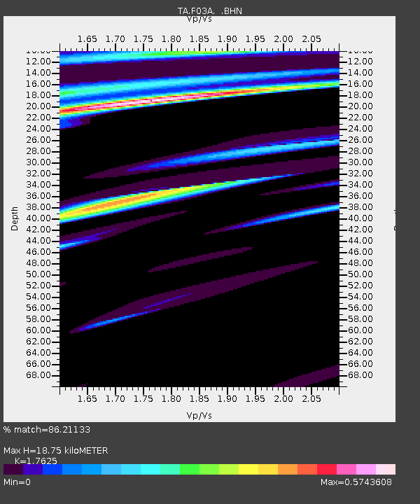
| Estimated Moho Depth: |
18.75 km |
| Estimated Crust Vp/Vs: |
1.76 |
| Assumed Crust Vp: |
6.566 km/s |
| Estimated Crust Vs: |
3.725 km/s |
| Estimated Crust Poisson's Ratio: |
0.26 |
|
| Radial Match: |
86.21133 % |
| Radial Bump: |
399 |
| Transverse Match: |
68.17492 % |
| Transverse Bump: |
400 |
| SOD ConfigId: |
2564 |
| Insert Time: |
2010-03-06 09:54:39.746 +0000 |
| GWidth: |
2.5 |
| Max Bumps: |
400 |
| Tol: |
0.001 |
|
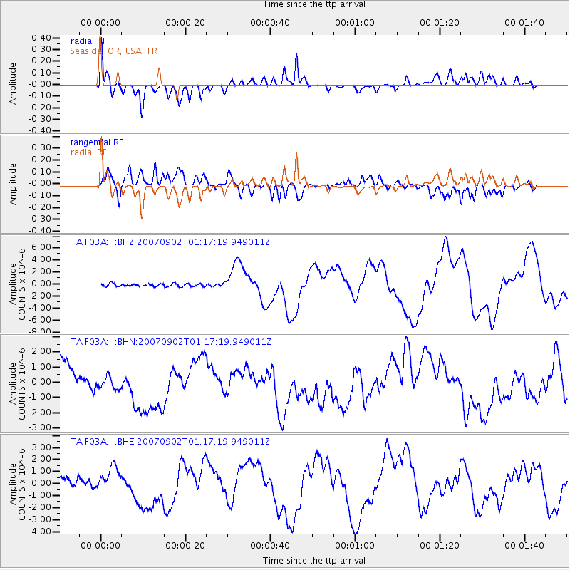
Signal To Noise
| Channel | StoN | STA | LTA |
| TA:F03A: :BHN:20070902T01:17:19.949011Z | 0.80121315 | 7.5747306E-7 | 9.454077E-7 |
| TA:F03A: :BHE:20070902T01:17:19.949011Z | 2.4476357 | 9.2001466E-7 | 3.7587893E-7 |
| TA:F03A: :BHZ:20070902T01:17:19.949011Z | 12.730346 | 2.8328952E-6 | 2.225309E-7 |
| Arrivals |
| Ps | 2.2 SECOND |
| PpPs | 7.7 SECOND |
| PsPs/PpSs | 9.9 SECOND |


