You are here: Home > Network List > TA - USArray Transportable Network (new EarthScope stations) Stations List
> Station K29M Barlow Dome, YT, CAN > Earthquake Result Viewer
K29M Barlow Dome, YT, CAN - Earthquake Result Viewer
| Earthquake location: |
New Britain Region, P.N.G. |
| Earthquake latitude/longitude: |
-5.5/151.5 |
| Earthquake time(UTC): |
2018/03/24 (083) 11:23:32 GMT |
| Earthquake Depth: |
36 km |
| Earthquake Magnitude: |
6.3 mww |
| Earthquake Catalog/Contributor: |
NEIC PDE/us |
|
| Network: |
TA USArray Transportable Network (new EarthScope stations) |
| Station: |
K29M Barlow Dome, YT, CAN |
| Lat/Lon: |
63.84 N/137.52 W |
| Elevation: |
1367 m |
|
| Distance: |
86.6 deg |
| Az: |
24.821 deg |
| Baz: |
250.537 deg |
| Ray Param: |
0.043854572 |
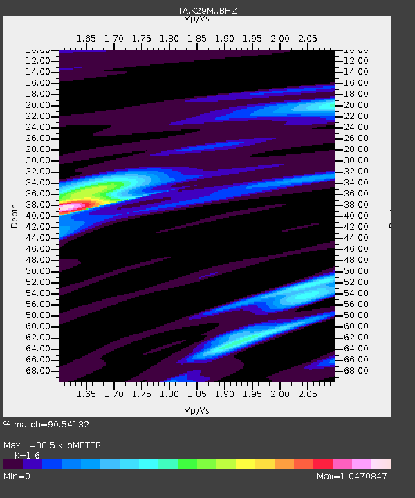
| Estimated Moho Depth: |
38.5 km |
| Estimated Crust Vp/Vs: |
1.60 |
| Assumed Crust Vp: |
6.566 km/s |
| Estimated Crust Vs: |
4.104 km/s |
| Estimated Crust Poisson's Ratio: |
0.18 |
|
| Radial Match: |
90.54132 % |
| Radial Bump: |
369 |
| Transverse Match: |
80.75979 % |
| Transverse Bump: |
400 |
| SOD ConfigId: |
13570011 |
| Insert Time: |
2019-04-30 00:00:36.974 +0000 |
| GWidth: |
2.5 |
| Max Bumps: |
400 |
| Tol: |
0.001 |
|

Signal To Noise
| Channel | StoN | STA | LTA |
| TA:K29M: :BHZ:20180324T11:35:41.050024Z | 23.005371 | 1.4406164E-6 | 6.262087E-8 |
| TA:K29M: :BHN:20180324T11:35:41.050024Z | 2.2465172 | 3.278998E-7 | 1.4595919E-7 |
| TA:K29M: :BHE:20180324T11:35:41.050024Z | 8.8733835 | 5.147446E-7 | 5.800996E-8 |
| Arrivals |
| Ps | 3.6 SECOND |
| PpPs | 15 SECOND |
| PsPs/PpSs | 18 SECOND |


