You are here: Home > Network List > TA - USArray Transportable Network (new EarthScope stations) Stations List
> Station N30M Aishikik Lake, Yukon, CAN > Earthquake Result Viewer
N30M Aishikik Lake, Yukon, CAN - Earthquake Result Viewer
| Earthquake location: |
New Britain Region, P.N.G. |
| Earthquake latitude/longitude: |
-5.5/151.5 |
| Earthquake time(UTC): |
2018/03/24 (083) 11:23:32 GMT |
| Earthquake Depth: |
36 km |
| Earthquake Magnitude: |
6.3 mww |
| Earthquake Catalog/Contributor: |
NEIC PDE/us |
|
| Network: |
TA USArray Transportable Network (new EarthScope stations) |
| Station: |
N30M Aishikik Lake, Yukon, CAN |
| Lat/Lon: |
61.46 N/137.09 W |
| Elevation: |
941 m |
|
| Distance: |
86.0 deg |
| Az: |
27.152 deg |
| Baz: |
251.069 deg |
| Ray Param: |
0.044284046 |
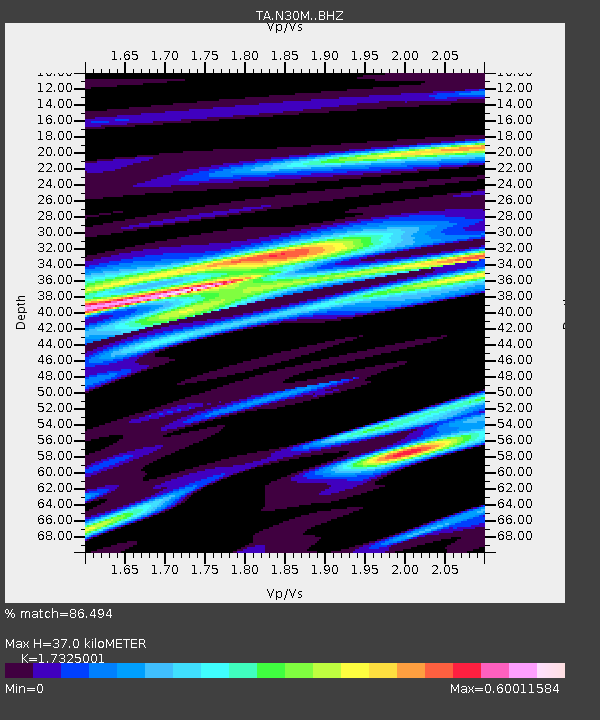
| Estimated Moho Depth: |
37.0 km |
| Estimated Crust Vp/Vs: |
1.73 |
| Assumed Crust Vp: |
6.566 km/s |
| Estimated Crust Vs: |
3.79 km/s |
| Estimated Crust Poisson's Ratio: |
0.25 |
|
| Radial Match: |
86.494 % |
| Radial Bump: |
400 |
| Transverse Match: |
82.837906 % |
| Transverse Bump: |
400 |
| SOD ConfigId: |
13570011 |
| Insert Time: |
2019-04-30 00:01:04.051 +0000 |
| GWidth: |
2.5 |
| Max Bumps: |
400 |
| Tol: |
0.001 |
|

Signal To Noise
| Channel | StoN | STA | LTA |
| TA:N30M: :BHZ:20180324T11:35:38.100012Z | 12.280305 | 1.4958667E-6 | 1.2181023E-7 |
| TA:N30M: :BHN:20180324T11:35:38.100012Z | 4.442746 | 2.6943E-7 | 6.064492E-8 |
| TA:N30M: :BHE:20180324T11:35:38.100012Z | 5.7468157 | 5.1973495E-7 | 9.043877E-8 |
| Arrivals |
| Ps | 4.2 SECOND |
| PpPs | 15 SECOND |
| PsPs/PpSs | 19 SECOND |


