You are here: Home > Network List > TA - USArray Transportable Network (new EarthScope stations) Stations List
> Station O17K Koliganek, Bristol Bay, AK, USA > Earthquake Result Viewer
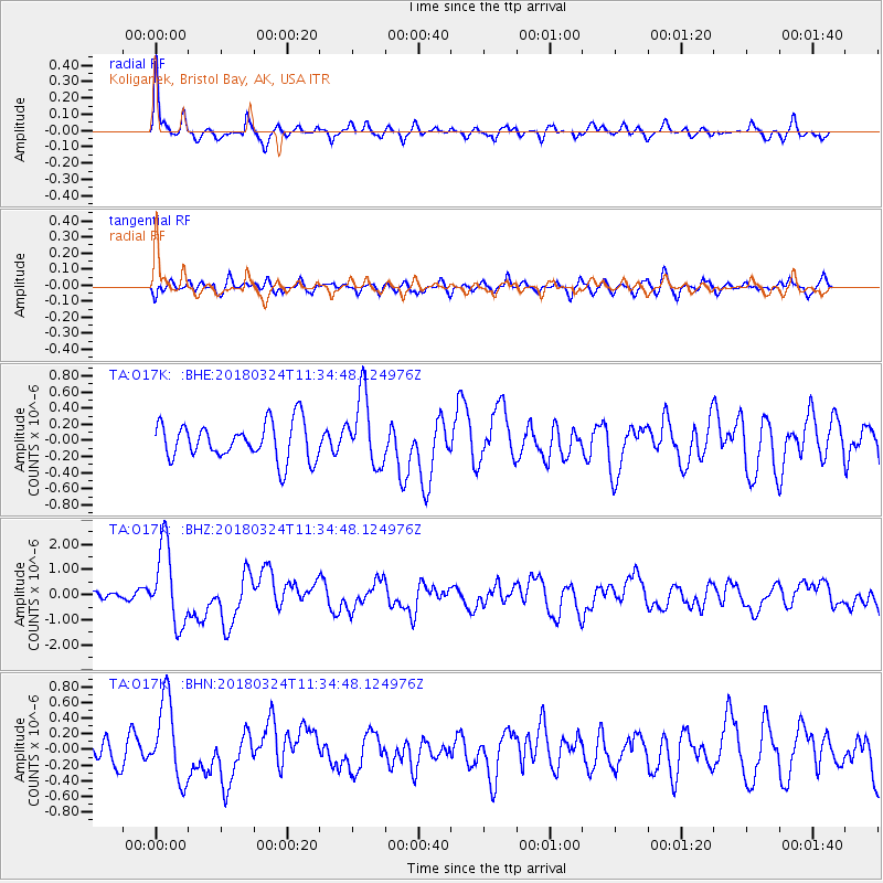
O17K Koliganek, Bristol Bay, AK, USA - Earthquake Result Viewer
*The percent match for this event was below the threshold and hence no stack was calculated.
| Earthquake location: |
New Britain Region, P.N.G. |
| Earthquake latitude/longitude: |
-5.5/151.5 |
| Earthquake time(UTC): |
2018/03/24 (083) 11:23:32 GMT |
| Earthquake Depth: |
36 km |
| Earthquake Magnitude: |
6.3 mww |
| Earthquake Catalog/Contributor: |
NEIC PDE/us |
|
| Network: |
TA USArray Transportable Network (new EarthScope stations) |
| Station: |
O17K Koliganek, Bristol Bay, AK, USA |
| Lat/Lon: |
59.77 N/157.09 W |
| Elevation: |
156 m |
|
| Distance: |
76.6 deg |
| Az: |
23.995 deg |
| Baz: |
233.141 deg |
| Ray Param: |
$rayparam |
*The percent match for this event was below the threshold and hence was not used in the summary stack. |
|
| Radial Match: |
67.786865 % |
| Radial Bump: |
337 |
| Transverse Match: |
66.67907 % |
| Transverse Bump: |
400 |
| SOD ConfigId: |
13570011 |
| Insert Time: |
2019-04-30 00:01:06.347 +0000 |
| GWidth: |
2.5 |
| Max Bumps: |
400 |
| Tol: |
0.001 |
|
Signal To Noise
| Channel | StoN | STA | LTA |
| TA:O17K: :BHZ:20180324T11:34:48.124976Z | 7.544208 | 1.5571837E-6 | 2.0640785E-7 |
| TA:O17K: :BHN:20180324T11:34:48.124976Z | 2.720781 | 5.114544E-7 | 1.8798073E-7 |
| TA:O17K: :BHE:20180324T11:34:48.124976Z | 1.8932731 | 4.359761E-7 | 2.3027638E-7 |
| Arrivals |
| Ps | |
| PpPs | |
| PsPs/PpSs | |


