You are here: Home > Network List > US - United States National Seismic Network Stations List
> Station HAWA Hanford, Washington, USA > Earthquake Result Viewer
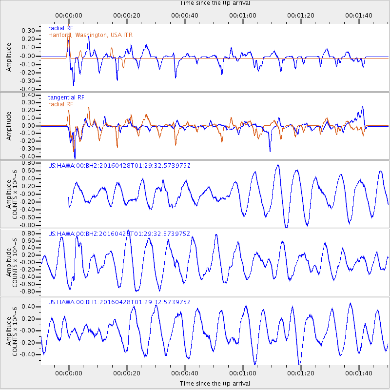
HAWA Hanford, Washington, USA - Earthquake Result Viewer
*The percent match for this event was below the threshold and hence no stack was calculated.
| Earthquake location: |
Solomon Islands |
| Earthquake latitude/longitude: |
-6.1/155.0 |
| Earthquake time(UTC): |
2016/04/28 (119) 01:17:13 GMT |
| Earthquake Depth: |
128 km |
| Earthquake Magnitude: |
5.6 MB |
| Earthquake Catalog/Contributor: |
NEIC PDE/NEIC ALERT |
|
| Network: |
US United States National Seismic Network |
| Station: |
HAWA Hanford, Washington, USA |
| Lat/Lon: |
46.39 N/119.53 W |
| Elevation: |
364 m |
|
| Distance: |
91.3 deg |
| Az: |
43.644 deg |
| Baz: |
262.58 deg |
| Ray Param: |
$rayparam |
*The percent match for this event was below the threshold and hence was not used in the summary stack. |
|
| Radial Match: |
79.03669 % |
| Radial Bump: |
400 |
| Transverse Match: |
78.37457 % |
| Transverse Bump: |
400 |
| SOD ConfigId: |
1475611 |
| Insert Time: |
2016-05-12 01:20:01.660 +0000 |
| GWidth: |
2.5 |
| Max Bumps: |
400 |
| Tol: |
0.001 |
|
Signal To Noise
| Channel | StoN | STA | LTA |
| US:HAWA:00:BHZ:20160428T01:29:32.573975Z | 2.76496 | 5.1956386E-7 | 1.8791009E-7 |
| US:HAWA:00:BH1:20160428T01:29:32.573975Z | 0.3929347 | 7.31644E-8 | 1.8619988E-7 |
| US:HAWA:00:BH2:20160428T01:29:32.573975Z | 1.1252012 | 1.9636411E-7 | 1.7451467E-7 |
| Arrivals |
| Ps | |
| PpPs | |
| PsPs/PpSs | |


