You are here: Home > Network List > TA - USArray Transportable Network (new EarthScope stations) Stations List
> Station F03A Seaside, OR, USA > Earthquake Result Viewer
F03A Seaside, OR, USA - Earthquake Result Viewer
| Earthquake location: |
Eastern Siberia, Russia |
| Earthquake latitude/longitude: |
60.5/167.5 |
| Earthquake time(UTC): |
2006/04/29 (119) 16:58:06 GMT |
| Earthquake Depth: |
11 km |
| Earthquake Magnitude: |
6.4 MB, 6.6 MS, 6.6 MW, 6.4 MW |
| Earthquake Catalog/Contributor: |
WHDF/NEIC |
|
| Network: |
TA USArray Transportable Network (new EarthScope stations) |
| Station: |
F03A Seaside, OR, USA |
| Lat/Lon: |
45.93 N/123.56 W |
| Elevation: |
325 m |
|
| Distance: |
41.7 deg |
| Az: |
78.163 deg |
| Baz: |
316.033 deg |
| Ray Param: |
0.073615514 |
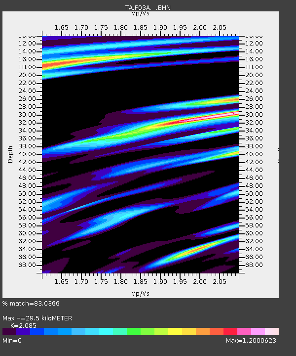
| Estimated Moho Depth: |
29.5 km |
| Estimated Crust Vp/Vs: |
2.09 |
| Assumed Crust Vp: |
6.566 km/s |
| Estimated Crust Vs: |
3.149 km/s |
| Estimated Crust Poisson's Ratio: |
0.35 |
|
| Radial Match: |
83.0366 % |
| Radial Bump: |
341 |
| Transverse Match: |
77.38355 % |
| Transverse Bump: |
400 |
| SOD ConfigId: |
2669 |
| Insert Time: |
2010-03-06 09:55:03.776 +0000 |
| GWidth: |
2.5 |
| Max Bumps: |
400 |
| Tol: |
0.001 |
|
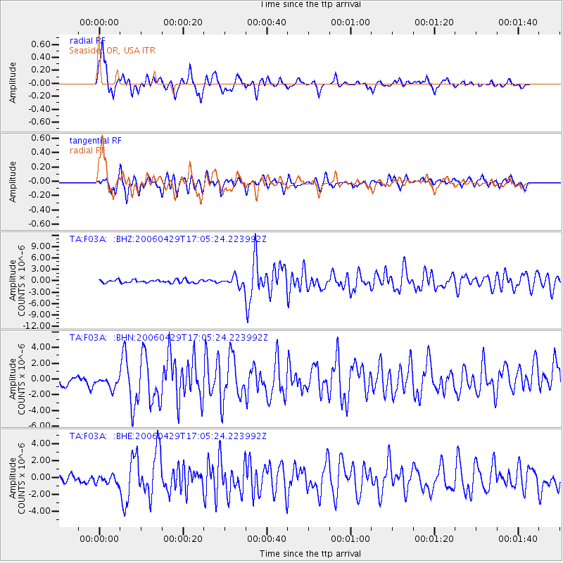
Signal To Noise
| Channel | StoN | STA | LTA |
| TA:F03A: :BHN:20060429T17:05:24.223992Z | 1.3790635 | 8.0026433E-7 | 5.802955E-7 |
| TA:F03A: :BHE:20060429T17:05:24.223992Z | 1.1409117 | 5.462178E-7 | 4.787555E-7 |
| TA:F03A: :BHZ:20060429T17:05:24.223992Z | 3.2791073 | 1.2676321E-6 | 3.8657842E-7 |
| Arrivals |
| Ps | 5.2 SECOND |
| PpPs | 13 SECOND |
| PsPs/PpSs | 18 SECOND |


