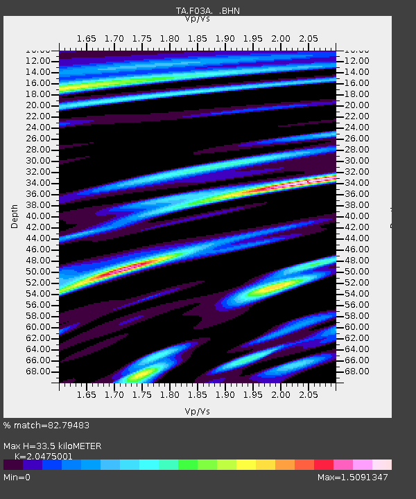
F03A Seaside, OR, USA - Earthquake Result Viewer
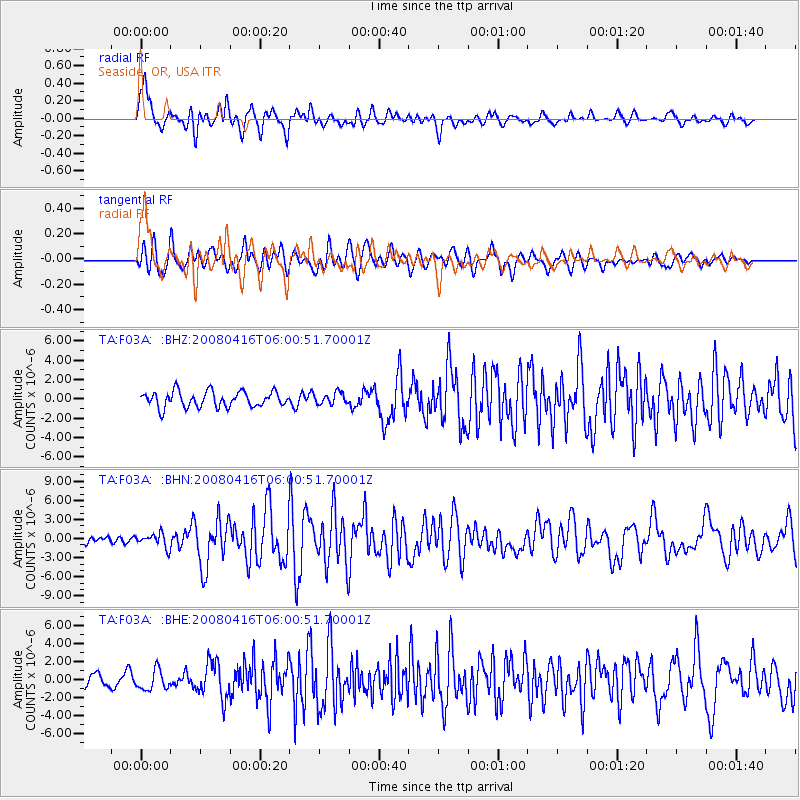
Earthquake location: Andreanof Islands, Aleutian Is.
Earthquake latitude/longitude: 51.9/-179.2
Earthquake time(UTC): 2008/04/16 (107) 05:54:19 GMT
Earthquake Depth: 13 km
Earthquake Magnitude: 6.1 MB, 6.5 MS, 6.6 MW, 6.6 MW
Earthquake Catalog/Contributor: WHDF/NEIC
Network: TA USArray Transportable Network (new EarthScope stations)
Station: F03A Seaside, OR, USA
Lat/Lon: 45.93 N/123.56 W
Elevation: 325 m
Distance: 36.3 deg
Az: 76.846 deg
Baz: 300.13 deg
Ray Param: 0.07677085
Estimated Moho Depth: 33.5 km
Estimated Crust Vp/Vs: 2.05
Assumed Crust Vp: 6.566 km/s
Estimated Crust Vs: 3.207 km/s
Estimated Crust Poisson's Ratio: 0.34
Radial Match: 82.79483 %
Radial Bump: 400
Transverse Match: 73.58888 %
Transverse Bump: 400
SOD ConfigId: 2504
Insert Time: 2010-03-06 09:55:19.414 +0000
GWidth: 2.5
Max Bumps: 400
Tol: 0.001

Signal To Noise

ChannelStoNSTALTA
TA:F03A: :BHN:20080416T06:00:51.70001Z1.78857231.096533E-66.1307725E-7
TA:F03A: :BHE:20080416T06:00:51.70001Z1.36361621.099335E-68.0619094E-7
TA:F03A: :BHZ:20080416T06:00:51.70001Z0.74857576.0344246E-78.0612085E-7
Arrivals
Ps5.7 SECOND
PpPs15 SECOND
PsPs/PpSs20 SECOND