You are here: Home > Network List > TA - USArray Transportable Network (new EarthScope stations) Stations List
> Station F03A Seaside, OR, USA > Earthquake Result Viewer
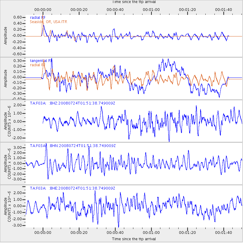
F03A Seaside, OR, USA - Earthquake Result Viewer
*The percent match for this event was below the threshold and hence no stack was calculated.
| Earthquake location: |
Kuril Islands |
| Earthquake latitude/longitude: |
51.0/157.6 |
| Earthquake time(UTC): |
2008/07/24 (206) 01:43:16 GMT |
| Earthquake Depth: |
27 km |
| Earthquake Magnitude: |
6.0 MB, 6.0 MS, 6.2 MW, 6.2 MW |
| Earthquake Catalog/Contributor: |
WHDF/NEIC |
|
| Network: |
TA USArray Transportable Network (new EarthScope stations) |
| Station: |
F03A Seaside, OR, USA |
| Lat/Lon: |
45.93 N/123.56 W |
| Elevation: |
325 m |
|
| Distance: |
50.2 deg |
| Az: |
63.038 deg |
| Baz: |
306.147 deg |
| Ray Param: |
$rayparam |
*The percent match for this event was below the threshold and hence was not used in the summary stack. |
|
| Radial Match: |
56.017017 % |
| Radial Bump: |
400 |
| Transverse Match: |
55.347767 % |
| Transverse Bump: |
400 |
| SOD ConfigId: |
2504 |
| Insert Time: |
2010-03-06 09:55:25.294 +0000 |
| GWidth: |
2.5 |
| Max Bumps: |
400 |
| Tol: |
0.001 |
|
Signal To Noise
| Channel | StoN | STA | LTA |
| TA:F03A: :BHN:20080724T01:51:38.749009Z | 5.5629053 | 1.6079985E-6 | 2.8905734E-7 |
| TA:F03A: :BHE:20080724T01:51:38.749009Z | 1.3706315 | 8.9426084E-7 | 6.524444E-7 |
| TA:F03A: :BHZ:20080724T01:51:38.749009Z | 1.8031076 | 7.776521E-7 | 4.3128435E-7 |
| Arrivals |
| Ps | |
| PpPs | |
| PsPs/PpSs | |


