You are here: Home > Network List > TA - USArray Transportable Network (new EarthScope stations) Stations List
> Station F03A Seaside, OR, USA > Earthquake Result Viewer
F03A Seaside, OR, USA - Earthquake Result Viewer
*The percent match for this event was below the threshold and hence no stack was calculated.
| Earthquake location: |
Virgin Islands |
| Earthquake latitude/longitude: |
19.2/-64.8 |
| Earthquake time(UTC): |
2008/10/11 (285) 10:40:14 GMT |
| Earthquake Depth: |
23 km |
| Earthquake Magnitude: |
6.1 MB, 5.9 MS, 6.1 MW, 6.0 MW |
| Earthquake Catalog/Contributor: |
WHDF/NEIC |
|
| Network: |
TA USArray Transportable Network (new EarthScope stations) |
| Station: |
F03A Seaside, OR, USA |
| Lat/Lon: |
45.93 N/123.56 W |
| Elevation: |
325 m |
|
| Distance: |
54.8 deg |
| Az: |
313.128 deg |
| Baz: |
98.707 deg |
| Ray Param: |
$rayparam |
*The percent match for this event was below the threshold and hence was not used in the summary stack. |
|
| Radial Match: |
77.82865 % |
| Radial Bump: |
400 |
| Transverse Match: |
69.41289 % |
| Transverse Bump: |
400 |
| SOD ConfigId: |
2560 |
| Insert Time: |
2010-03-06 09:55:56.884 +0000 |
| GWidth: |
2.5 |
| Max Bumps: |
400 |
| Tol: |
0.001 |
|
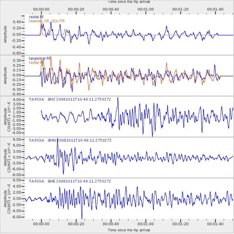
Signal To Noise
| Channel | StoN | STA | LTA |
| TA:F03A: :BHN:20081011T10:49:11.275027Z | 2.8360085 | 1.0790984E-6 | 3.8049902E-7 |
| TA:F03A: :BHE:20081011T10:49:11.275027Z | 0.6562551 | 4.82523E-7 | 7.3526735E-7 |
| TA:F03A: :BHZ:20081011T10:49:11.275027Z | 0.6585975 | 4.6057104E-7 | 6.993209E-7 |
| Arrivals |
| Ps | |
| PpPs | |
| PsPs/PpSs | |


