You are here: Home > Network List > TA - USArray Transportable Network (new EarthScope stations) Stations List
> Station F03A Seaside, OR, USA > Earthquake Result Viewer
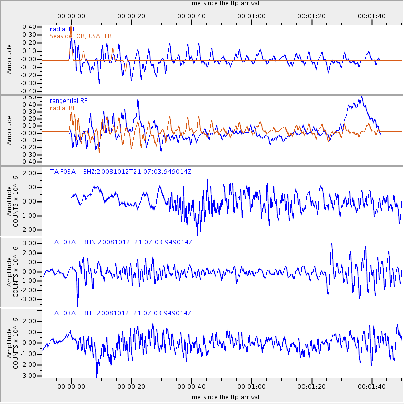
F03A Seaside, OR, USA - Earthquake Result Viewer
*The percent match for this event was below the threshold and hence no stack was calculated.
| Earthquake location: |
Southern Bolivia |
| Earthquake latitude/longitude: |
-20.1/-65.0 |
| Earthquake time(UTC): |
2008/10/12 (286) 20:55:41 GMT |
| Earthquake Depth: |
353 km |
| Earthquake Magnitude: |
6.0 MB, 6.2 MW, 6.2 MW |
| Earthquake Catalog/Contributor: |
WHDF/NEIC |
|
| Network: |
TA USArray Transportable Network (new EarthScope stations) |
| Station: |
F03A Seaside, OR, USA |
| Lat/Lon: |
45.93 N/123.56 W |
| Elevation: |
325 m |
|
| Distance: |
84.4 deg |
| Az: |
323.24 deg |
| Baz: |
126.315 deg |
| Ray Param: |
$rayparam |
*The percent match for this event was below the threshold and hence was not used in the summary stack. |
|
| Radial Match: |
56.019085 % |
| Radial Bump: |
400 |
| Transverse Match: |
44.759422 % |
| Transverse Bump: |
400 |
| SOD ConfigId: |
2560 |
| Insert Time: |
2010-03-06 09:55:58.163 +0000 |
| GWidth: |
2.5 |
| Max Bumps: |
400 |
| Tol: |
0.001 |
|
Signal To Noise
| Channel | StoN | STA | LTA |
| TA:F03A: :BHN:20081012T21:07:03.949014Z | 5.8038306 | 1.1166059E-6 | 1.923912E-7 |
| TA:F03A: :BHE:20081012T21:07:03.949014Z | 1.2812309 | 5.6056115E-7 | 4.3751763E-7 |
| TA:F03A: :BHZ:20081012T21:07:03.949014Z | 1.3105567 | 4.9847904E-7 | 3.8035674E-7 |
| Arrivals |
| Ps | |
| PpPs | |
| PsPs/PpSs | |


