You are here: Home > Network List > TA - USArray Transportable Network (new EarthScope stations) Stations List
> Station F03A Seaside, OR, USA > Earthquake Result Viewer
F03A Seaside, OR, USA - Earthquake Result Viewer
*The percent match for this event was below the threshold and hence no stack was calculated.
| Earthquake location: |
South Of Mariana Islands |
| Earthquake latitude/longitude: |
12.5/143.2 |
| Earthquake time(UTC): |
2008/05/09 (130) 21:51:29 GMT |
| Earthquake Depth: |
76 km |
| Earthquake Magnitude: |
6.1 MB, 6.7 MW, 6.7 MW |
| Earthquake Catalog/Contributor: |
WHDF/NEIC |
|
| Network: |
TA USArray Transportable Network (new EarthScope stations) |
| Station: |
F03A Seaside, OR, USA |
| Lat/Lon: |
45.93 N/123.56 W |
| Elevation: |
325 m |
|
| Distance: |
83.4 deg |
| Az: |
44.547 deg |
| Baz: |
281.031 deg |
| Ray Param: |
$rayparam |
*The percent match for this event was below the threshold and hence was not used in the summary stack. |
|
| Radial Match: |
78.68705 % |
| Radial Bump: |
400 |
| Transverse Match: |
64.93545 % |
| Transverse Bump: |
400 |
| SOD ConfigId: |
2504 |
| Insert Time: |
2010-03-06 09:56:15.760 +0000 |
| GWidth: |
2.5 |
| Max Bumps: |
400 |
| Tol: |
0.001 |
|
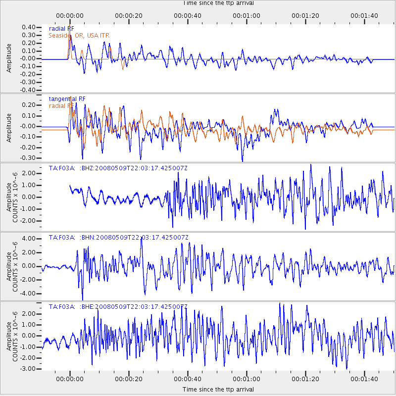
Signal To Noise
| Channel | StoN | STA | LTA |
| TA:F03A: :BHN:20080509T22:03:17.425007Z | 7.5414643 | 1.5400494E-6 | 2.0421093E-7 |
| TA:F03A: :BHE:20080509T22:03:17.425007Z | 0.97645634 | 8.6243614E-7 | 8.832306E-7 |
| TA:F03A: :BHZ:20080509T22:03:17.425007Z | 1.5283155 | 6.538288E-7 | 4.2781005E-7 |
| Arrivals |
| Ps | |
| PpPs | |
| PsPs/PpSs | |


