You are here: Home > Network List > TA - USArray Transportable Network (new EarthScope stations) Stations List
> Station F03A Seaside, OR, USA > Earthquake Result Viewer
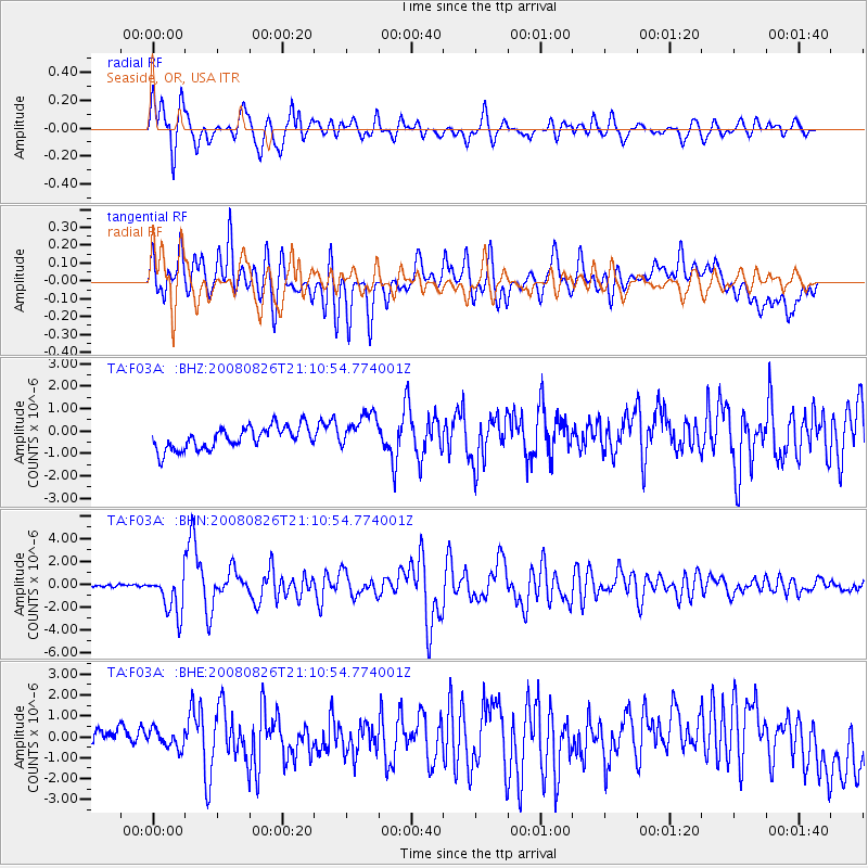
F03A Seaside, OR, USA - Earthquake Result Viewer
*The percent match for this event was below the threshold and hence no stack was calculated.
| Earthquake location: |
Peru-Brazil Border Region |
| Earthquake latitude/longitude: |
-7.6/-74.4 |
| Earthquake time(UTC): |
2008/08/26 (239) 21:00:36 GMT |
| Earthquake Depth: |
154 km |
| Earthquake Magnitude: |
6.0 MB, 6.4 MW, 6.4 MW |
| Earthquake Catalog/Contributor: |
WHDF/NEIC |
|
| Network: |
TA USArray Transportable Network (new EarthScope stations) |
| Station: |
F03A Seaside, OR, USA |
| Lat/Lon: |
45.93 N/123.56 W |
| Elevation: |
325 m |
|
| Distance: |
69.0 deg |
| Az: |
325.556 deg |
| Baz: |
126.555 deg |
| Ray Param: |
$rayparam |
*The percent match for this event was below the threshold and hence was not used in the summary stack. |
|
| Radial Match: |
79.180115 % |
| Radial Bump: |
400 |
| Transverse Match: |
57.50154 % |
| Transverse Bump: |
400 |
| SOD ConfigId: |
2504 |
| Insert Time: |
2010-03-06 09:56:35.286 +0000 |
| GWidth: |
2.5 |
| Max Bumps: |
400 |
| Tol: |
0.001 |
|
Signal To Noise
| Channel | StoN | STA | LTA |
| TA:F03A: :BHN:20080826T21:10:54.774001Z | 10.805033 | 1.8123595E-6 | 1.677329E-7 |
| TA:F03A: :BHE:20080826T21:10:54.774001Z | 0.86324984 | 5.025107E-7 | 5.8211504E-7 |
| TA:F03A: :BHZ:20080826T21:10:54.774001Z | 1.6360979 | 8.1909536E-7 | 5.006396E-7 |
| Arrivals |
| Ps | |
| PpPs | |
| PsPs/PpSs | |


