You are here: Home > Network List > TA - USArray Transportable Network (new EarthScope stations) Stations List
> Station F03A Seaside, OR, USA > Earthquake Result Viewer
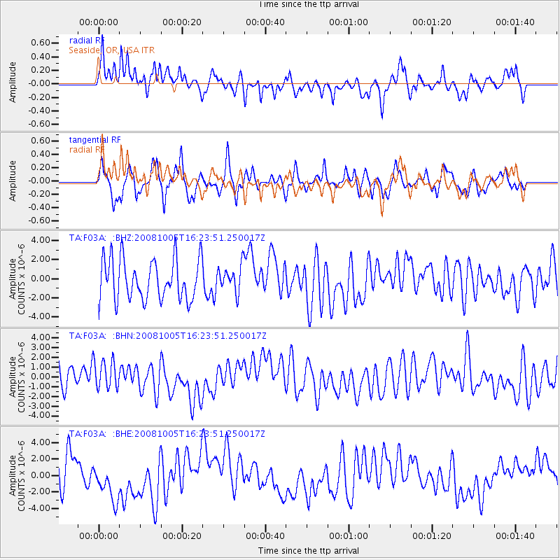
F03A Seaside, OR, USA - Earthquake Result Viewer
*The percent match for this event was below the threshold and hence no stack was calculated.
| Earthquake location: |
Tajikistan-Xinjiang Border Reg. |
| Earthquake latitude/longitude: |
39.5/73.9 |
| Earthquake time(UTC): |
2008/10/05 (279) 16:11:10 GMT |
| Earthquake Depth: |
35 km |
| Earthquake Magnitude: |
5.6 MB |
| Earthquake Catalog/Contributor: |
WHDF/NEIC |
|
| Network: |
TA USArray Transportable Network (new EarthScope stations) |
| Station: |
F03A Seaside, OR, USA |
| Lat/Lon: |
45.93 N/123.56 W |
| Elevation: |
325 m |
|
| Distance: |
93.5 deg |
| Az: |
12.102 deg |
| Baz: |
346.562 deg |
| Ray Param: |
$rayparam |
*The percent match for this event was below the threshold and hence was not used in the summary stack. |
|
| Radial Match: |
68.09408 % |
| Radial Bump: |
400 |
| Transverse Match: |
55.560143 % |
| Transverse Bump: |
400 |
| SOD ConfigId: |
2560 |
| Insert Time: |
2010-03-06 09:56:45.546 +0000 |
| GWidth: |
2.5 |
| Max Bumps: |
400 |
| Tol: |
0.001 |
|
Signal To Noise
| Channel | StoN | STA | LTA |
| TA:F03A: :BHN:20081005T16:23:51.250017Z | 1.412306 | 1.3697565E-6 | 9.698724E-7 |
| TA:F03A: :BHE:20081005T16:23:51.250017Z | 1.3868282 | 2.6790656E-6 | 1.9317936E-6 |
| TA:F03A: :BHZ:20081005T16:23:51.250017Z | 0.66428864 | 1.406556E-6 | 2.1173867E-6 |
| Arrivals |
| Ps | |
| PpPs | |
| PsPs/PpSs | |


