You are here: Home > Network List > TA - USArray Transportable Network (new EarthScope stations) Stations List
> Station F03A Seaside, OR, USA > Earthquake Result Viewer
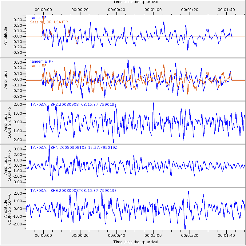
F03A Seaside, OR, USA - Earthquake Result Viewer
*The percent match for this event was below the threshold and hence no stack was calculated.
| Earthquake location: |
Vanuatu Islands |
| Earthquake latitude/longitude: |
-20.0/169.1 |
| Earthquake time(UTC): |
2008/09/08 (252) 03:03:15 GMT |
| Earthquake Depth: |
36 km |
| Earthquake Magnitude: |
6.0 MB, 5.8 MS, 6.2 MW, 6.2 MW |
| Earthquake Catalog/Contributor: |
WHDF/NEIC |
|
| Network: |
TA USArray Transportable Network (new EarthScope stations) |
| Station: |
F03A Seaside, OR, USA |
| Lat/Lon: |
45.93 N/123.56 W |
| Elevation: |
325 m |
|
| Distance: |
89.4 deg |
| Az: |
40.095 deg |
| Baz: |
240.23 deg |
| Ray Param: |
$rayparam |
*The percent match for this event was below the threshold and hence was not used in the summary stack. |
|
| Radial Match: |
56.57869 % |
| Radial Bump: |
400 |
| Transverse Match: |
63.645046 % |
| Transverse Bump: |
400 |
| SOD ConfigId: |
2504 |
| Insert Time: |
2010-03-06 09:56:50.889 +0000 |
| GWidth: |
2.5 |
| Max Bumps: |
400 |
| Tol: |
0.001 |
|
Signal To Noise
| Channel | StoN | STA | LTA |
| TA:F03A: :BHN:20080908T03:15:37.799019Z | 3.314394 | 1.2520435E-6 | 3.7775942E-7 |
| TA:F03A: :BHE:20080908T03:15:37.799019Z | 0.996609 | 4.7384876E-7 | 4.7546104E-7 |
| TA:F03A: :BHZ:20080908T03:15:37.799019Z | 0.7319768 | 6.6420284E-7 | 9.0740974E-7 |
| Arrivals |
| Ps | |
| PpPs | |
| PsPs/PpSs | |


