You are here: Home > Network List > TA - USArray Transportable Network (new EarthScope stations) Stations List
> Station O17K Koliganek, Bristol Bay, AK, USA > Earthquake Result Viewer
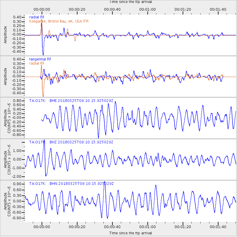
O17K Koliganek, Bristol Bay, AK, USA - Earthquake Result Viewer
*The percent match for this event was below the threshold and hence no stack was calculated.
| Earthquake location: |
Banda Sea |
| Earthquake latitude/longitude: |
-7.3/128.5 |
| Earthquake time(UTC): |
2018/03/25 (084) 08:58:11 GMT |
| Earthquake Depth: |
149 km |
| Earthquake Magnitude: |
5.6 Mww |
| Earthquake Catalog/Contributor: |
NEIC PDE/us |
|
| Network: |
TA USArray Transportable Network (new EarthScope stations) |
| Station: |
O17K Koliganek, Bristol Bay, AK, USA |
| Lat/Lon: |
59.77 N/157.09 W |
| Elevation: |
156 m |
|
| Distance: |
88.5 deg |
| Az: |
29.175 deg |
| Baz: |
252.896 deg |
| Ray Param: |
$rayparam |
*The percent match for this event was below the threshold and hence was not used in the summary stack. |
|
| Radial Match: |
78.584854 % |
| Radial Bump: |
400 |
| Transverse Match: |
65.830666 % |
| Transverse Bump: |
400 |
| SOD ConfigId: |
13570011 |
| Insert Time: |
2019-04-30 00:09:00.582 +0000 |
| GWidth: |
2.5 |
| Max Bumps: |
400 |
| Tol: |
0.001 |
|
Signal To Noise
| Channel | StoN | STA | LTA |
| TA:O17K: :BHZ:20180325T09:10:15.925029Z | 2.7823668 | 1.2092688E-6 | 4.3461878E-7 |
| TA:O17K: :BHN:20180325T09:10:15.925029Z | 1.6963805 | 3.7777522E-7 | 2.2269487E-7 |
| TA:O17K: :BHE:20180325T09:10:15.925029Z | 1.2921569 | 4.1946186E-7 | 3.2462142E-7 |
| Arrivals |
| Ps | |
| PpPs | |
| PsPs/PpSs | |


