You are here: Home > Network List > BK - Berkeley Digital Seismograph Network Stations List
> Station HUMO Hull Mountain, OR > Earthquake Result Viewer
HUMO Hull Mountain, OR - Earthquake Result Viewer

| Earthquake location: |
Vanuatu Islands |
| Earthquake latitude/longitude: |
-16.1/167.3 |
| Earthquake time(UTC): |
2016/04/28 (119) 19:33:27 GMT |
| Earthquake Depth: |
35 km |
| Earthquake Magnitude: |
7.0 MO |
| Earthquake Catalog/Contributor: |
NEIC PDE/NEIC ALERT |
|
| Network: |
BK Berkeley Digital Seismograph Network |
| Station: |
HUMO Hull Mountain, OR |
| Lat/Lon: |
42.61 N/122.96 W |
| Elevation: |
555 m |
|
| Distance: |
86.5 deg |
| Az: |
43.925 deg |
| Baz: |
244.592 deg |
| Ray Param: |
0.043929927 |
| Estimated Moho Depth: |
23.25 km |
| Estimated Crust Vp/Vs: |
2.10 |
| Assumed Crust Vp: |
6.522 km/s |
| Estimated Crust Vs: |
3.109 km/s |
| Estimated Crust Poisson's Ratio: |
0.35 |
|
| Radial Match: |
93.483055 % |
| Radial Bump: |
400 |
| Transverse Match: |
67.84547 % |
| Transverse Bump: |
400 |
| SOD ConfigId: |
1475611 |
| Insert Time: |
2016-05-12 19:55:16.439 +0000 |
| GWidth: |
2.5 |
| Max Bumps: |
400 |
| Tol: |
0.001 |
|
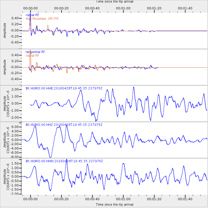
Signal To Noise
| Channel | StoN | STA | LTA |
| BK:HUMO:00:HHZ:20160428T19:45:35.237976Z | 16.588251 | 3.891148E-6 | 2.3457254E-7 |
| BK:HUMO:00:HHN:20160428T19:45:35.237976Z | 3.5338926 | 7.424571E-7 | 2.100961E-7 |
| BK:HUMO:00:HHE:20160428T19:45:35.237976Z | 4.6210723 | 1.1464039E-6 | 2.480818E-7 |
| Arrivals |
| Ps | 4.0 SECOND |
| PpPs | 11 SECOND |
| PsPs/PpSs | 15 SECOND |


