You are here: Home > Network List > CI - Caltech Regional Seismic Network Stations List
> Station JCS Julian Camp Stevens, California, USA > Earthquake Result Viewer
JCS Julian Camp Stevens, California, USA - Earthquake Result Viewer
| Earthquake location: |
Fiji Islands Region |
| Earthquake latitude/longitude: |
-20.3/-177.8 |
| Earthquake time(UTC): |
2001/05/26 (146) 10:57:26 GMT |
| Earthquake Depth: |
406 km |
| Earthquake Magnitude: |
5.3 MB, 6.4 MW, 6.4 MW |
| Earthquake Catalog/Contributor: |
WHDF/NEIC |
|
| Network: |
CI Caltech Regional Seismic Network |
| Station: |
JCS Julian Camp Stevens, California, USA |
| Lat/Lon: |
33.09 N/116.60 W |
| Elevation: |
1258 m |
|
| Distance: |
78.9 deg |
| Az: |
48.584 deg |
| Baz: |
236.983 deg |
| Ray Param: |
0.048153803 |
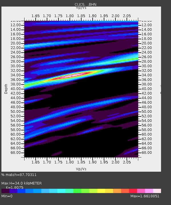
| Estimated Moho Depth: |
34.0 km |
| Estimated Crust Vp/Vs: |
1.81 |
| Assumed Crust Vp: |
6.264 km/s |
| Estimated Crust Vs: |
3.465 km/s |
| Estimated Crust Poisson's Ratio: |
0.28 |
|
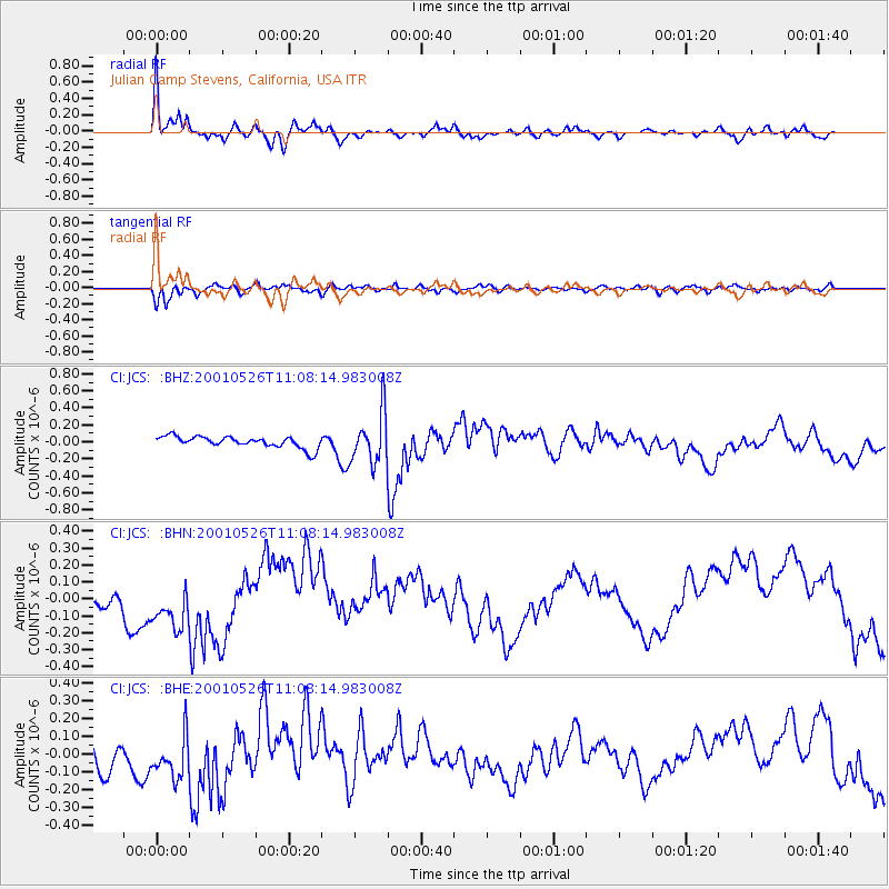
| Radial Match: |
87.70311 % |
| Radial Bump: |
282 |
| Transverse Match: |
79.68658 % |
| Transverse Bump: |
349 |
| SOD ConfigId: |
3770 |
| Insert Time: |
2010-02-26 01:52:36.976 +0000 |
| GWidth: |
2.5 |
| Max Bumps: |
400 |
| Tol: |
0.001 |
|
Signal To Noise
| Channel | StoN | STA | LTA |
| CI:JCS: :BHN:20010526T11:08:14.983008Z | 3.1549773 | 1.486061E-7 | 4.7102112E-8 |
| CI:JCS: :BHE:20010526T11:08:14.983008Z | 1.9741489 | 1.2154302E-7 | 6.15673E-8 |
| CI:JCS: :BHZ:20010526T11:08:14.983008Z | 4.4179416 | 2.9802786E-7 | 6.745854E-8 |
| Arrivals |
| Ps | 4.5 SECOND |
| PpPs | 15 SECOND |
| PsPs/PpSs | 19 SECOND |


