You are here: Home > Network List > TA - USArray Transportable Network (new EarthScope stations) Stations List
> Station 528A Cox Ranch, Sanderson, TX, USA > Earthquake Result Viewer
528A Cox Ranch, Sanderson, TX, USA - Earthquake Result Viewer
| Earthquake location: |
Vanuatu Islands |
| Earthquake latitude/longitude: |
-13.0/166.5 |
| Earthquake time(UTC): |
2009/10/07 (280) 22:03:14 GMT |
| Earthquake Depth: |
45 km |
| Earthquake Magnitude: |
6.4 MB, 7.3 MS, 7.6 MW, 7.7 MW |
| Earthquake Catalog/Contributor: |
WHDF/NEIC |
|
| Network: |
TA USArray Transportable Network (new EarthScope stations) |
| Station: |
528A Cox Ranch, Sanderson, TX, USA |
| Lat/Lon: |
30.16 N/102.79 W |
| Elevation: |
1183 m |
|
| Distance: |
97.0 deg |
| Az: |
60.755 deg |
| Baz: |
259.099 deg |
| Ray Param: |
0.040314592 |
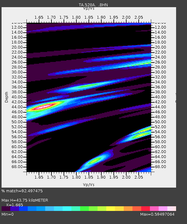
| Estimated Moho Depth: |
43.75 km |
| Estimated Crust Vp/Vs: |
1.66 |
| Assumed Crust Vp: |
6.121 km/s |
| Estimated Crust Vs: |
3.676 km/s |
| Estimated Crust Poisson's Ratio: |
0.22 |
|
| Radial Match: |
92.497475 % |
| Radial Bump: |
305 |
| Transverse Match: |
66.0758 % |
| Transverse Bump: |
400 |
| SOD ConfigId: |
2622 |
| Insert Time: |
2010-03-06 09:57:55.532 +0000 |
| GWidth: |
2.5 |
| Max Bumps: |
400 |
| Tol: |
0.001 |
|
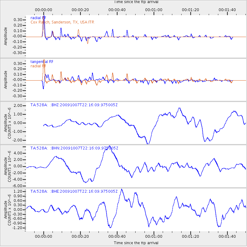
Signal To Noise
| Channel | StoN | STA | LTA |
| TA:528A: :BHN:20091007T22:16:09.975005Z | 3.6340435 | 9.5143537E-7 | 2.6181178E-7 |
| TA:528A: :BHE:20091007T22:16:09.975005Z | 0.6163749 | 1.5587668E-7 | 2.5289262E-7 |
| TA:528A: :BHZ:20091007T22:16:09.975005Z | 1.165987 | 2.9161663E-7 | 2.501028E-7 |
| Arrivals |
| Ps | 4.8 SECOND |
| PpPs | 19 SECOND |
| PsPs/PpSs | 24 SECOND |


