You are here: Home > Network List > TA - USArray Transportable Network (new EarthScope stations) Stations List
> Station 528A Cox Ranch, Sanderson, TX, USA > Earthquake Result Viewer
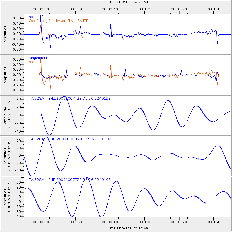
528A Cox Ranch, Sanderson, TX, USA - Earthquake Result Viewer

| Earthquake location: |
Santa Cruz Islands |
| Earthquake latitude/longitude: |
-12.6/166.0 |
| Earthquake time(UTC): |
2009/10/07 (280) 23:23:28 GMT |
| Earthquake Depth: |
36 km |
| Earthquake Magnitude: |
5.5 MB |
| Earthquake Catalog/Contributor: |
WHDF/NEIC |
|
| Network: |
TA USArray Transportable Network (new EarthScope stations) |
| Station: |
528A Cox Ranch, Sanderson, TX, USA |
| Lat/Lon: |
30.16 N/102.79 W |
| Elevation: |
1183 m |
|
| Distance: |
97.3 deg |
| Az: |
60.796 deg |
| Baz: |
259.75 deg |
| Ray Param: |
0.04024618 |
| Estimated Moho Depth: |
49.75 km |
| Estimated Crust Vp/Vs: |
1.86 |
| Assumed Crust Vp: |
6.121 km/s |
| Estimated Crust Vs: |
3.291 km/s |
| Estimated Crust Poisson's Ratio: |
0.30 |
|
| Radial Match: |
81.55211 % |
| Radial Bump: |
400 |
| Transverse Match: |
91.6544 % |
| Transverse Bump: |
207 |
| SOD ConfigId: |
2622 |
| Insert Time: |
2010-03-06 09:57:59.939 +0000 |
| GWidth: |
2.5 |
| Max Bumps: |
400 |
| Tol: |
0.001 |
|
Signal To Noise
| Channel | StoN | STA | LTA |
| TA:528A: :BHN:20091007T23:36:26.224019Z | 1.3918083 | 4.1340903E-5 | 2.9703015E-5 |
| TA:528A: :BHE:20091007T23:36:26.224019Z | 2.937747 | 2.600067E-5 | 8.850548E-6 |
| TA:528A: :BHZ:20091007T23:36:26.224019Z | 0.7638929 | 2.338451E-5 | 3.061229E-5 |
| Arrivals |
| Ps | 7.1 SECOND |
| PpPs | 23 SECOND |
| PsPs/PpSs | 30 SECOND |


