You are here: Home > Network List > AV - Alaska Volcano Observatory Stations List
> Station AMKA Regional Station, Amchitka Island, Alaska > Earthquake Result Viewer
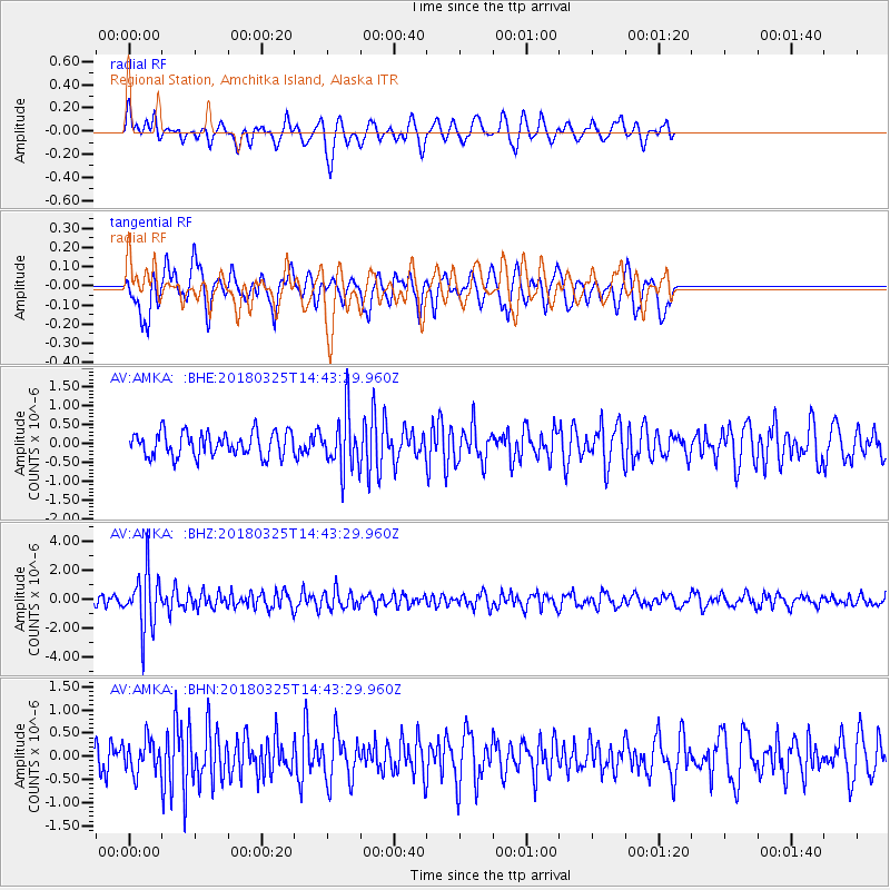
AMKA Regional Station, Amchitka Island, Alaska - Earthquake Result Viewer
*The percent match for this event was below the threshold and hence no stack was calculated.
| Earthquake location: |
Southeast Of Honshu, Japan |
| Earthquake latitude/longitude: |
32.6/140.6 |
| Earthquake time(UTC): |
2018/03/25 (084) 14:37:23 GMT |
| Earthquake Depth: |
51 km |
| Earthquake Magnitude: |
5.7 Mww |
| Earthquake Catalog/Contributor: |
NEIC PDE/us |
|
| Network: |
AV Alaska Volcano Observatory |
| Station: |
AMKA Regional Station, Amchitka Island, Alaska |
| Lat/Lon: |
51.38 N/179.30 E |
| Elevation: |
116 m |
|
| Distance: |
33.8 deg |
| Az: |
44.721 deg |
| Baz: |
251.385 deg |
| Ray Param: |
$rayparam |
*The percent match for this event was below the threshold and hence was not used in the summary stack. |
|
| Radial Match: |
61.719006 % |
| Radial Bump: |
381 |
| Transverse Match: |
59.61724 % |
| Transverse Bump: |
400 |
| SOD ConfigId: |
13570011 |
| Insert Time: |
2019-04-30 00:18:34.267 +0000 |
| GWidth: |
2.5 |
| Max Bumps: |
400 |
| Tol: |
0.001 |
|
Signal To Noise
| Channel | StoN | STA | LTA |
| AV:AMKA: :BHZ:20180325T14:43:29.960Z | 6.1462836 | 1.963276E-6 | 3.1942488E-7 |
| AV:AMKA: :BHN:20180325T14:43:29.960Z | 1.0525426 | 3.5967625E-7 | 3.4172135E-7 |
| AV:AMKA: :BHE:20180325T14:43:29.960Z | 2.3945124 | 7.610556E-7 | 3.178332E-7 |
| Arrivals |
| Ps | |
| PpPs | |
| PsPs/PpSs | |


