You are here: Home > Network List > TA - USArray Transportable Network (new EarthScope stations) Stations List
> Station 528A Cox Ranch, Sanderson, TX, USA > Earthquake Result Viewer
528A Cox Ranch, Sanderson, TX, USA - Earthquake Result Viewer
| Earthquake location: |
Southern Peru |
| Earthquake latitude/longitude: |
-15.0/-70.4 |
| Earthquake time(UTC): |
2009/07/12 (193) 06:12:47 GMT |
| Earthquake Depth: |
199 km |
| Earthquake Magnitude: |
5.7 MB, 6.1 MW, 6.1 MW |
| Earthquake Catalog/Contributor: |
WHDF/NEIC |
|
| Network: |
TA USArray Transportable Network (new EarthScope stations) |
| Station: |
528A Cox Ranch, Sanderson, TX, USA |
| Lat/Lon: |
30.16 N/102.79 W |
| Elevation: |
1183 m |
|
| Distance: |
54.7 deg |
| Az: |
325.403 deg |
| Baz: |
140.696 deg |
| Ray Param: |
0.064600706 |
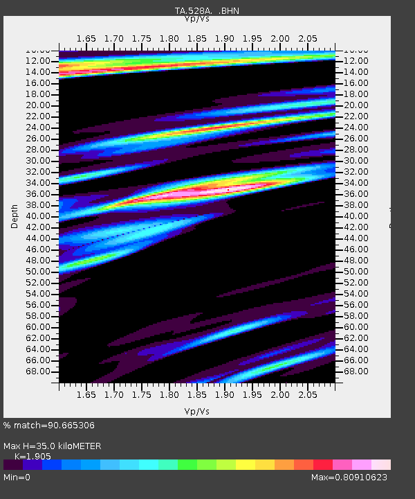
| Estimated Moho Depth: |
35.0 km |
| Estimated Crust Vp/Vs: |
1.90 |
| Assumed Crust Vp: |
6.121 km/s |
| Estimated Crust Vs: |
3.213 km/s |
| Estimated Crust Poisson's Ratio: |
0.31 |
|
| Radial Match: |
90.665306 % |
| Radial Bump: |
400 |
| Transverse Match: |
67.99481 % |
| Transverse Bump: |
400 |
| SOD ConfigId: |
2648 |
| Insert Time: |
2010-03-06 09:58:23.853 +0000 |
| GWidth: |
2.5 |
| Max Bumps: |
400 |
| Tol: |
0.001 |
|
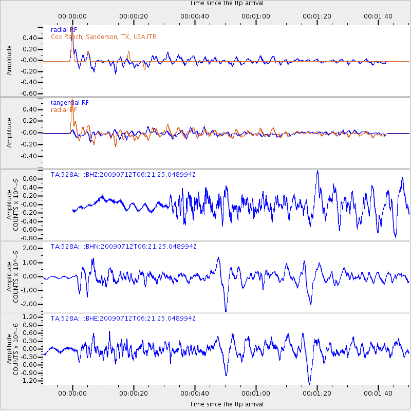
Signal To Noise
| Channel | StoN | STA | LTA |
| TA:528A: :BHN:20090712T06:21:25.048994Z | 5.490074 | 5.145267E-7 | 9.3719436E-8 |
| TA:528A: :BHE:20090712T06:21:25.048994Z | 2.1482384 | 1.7672846E-7 | 8.226669E-8 |
| TA:528A: :BHZ:20090712T06:21:25.048994Z | 1.2978239 | 1.1734606E-7 | 9.041755E-8 |
| Arrivals |
| Ps | 5.4 SECOND |
| PpPs | 16 SECOND |
| PsPs/PpSs | 21 SECOND |


