You are here: Home > Network List > TA - USArray Transportable Network (new EarthScope stations) Stations List
> Station 528A Cox Ranch, Sanderson, TX, USA > Earthquake Result Viewer
528A Cox Ranch, Sanderson, TX, USA - Earthquake Result Viewer
| Earthquake location: |
Kuril Islands |
| Earthquake latitude/longitude: |
46.0/151.5 |
| Earthquake time(UTC): |
2009/04/07 (097) 04:23:33 GMT |
| Earthquake Depth: |
31 km |
| Earthquake Magnitude: |
6.5 MB, 6.8 MS, 6.9 MW, 6.9 MW |
| Earthquake Catalog/Contributor: |
WHDF/NEIC |
|
| Network: |
TA USArray Transportable Network (new EarthScope stations) |
| Station: |
528A Cox Ranch, Sanderson, TX, USA |
| Lat/Lon: |
30.16 N/102.79 W |
| Elevation: |
1183 m |
|
| Distance: |
78.7 deg |
| Az: |
58.253 deg |
| Baz: |
316.856 deg |
| Ray Param: |
0.049420007 |
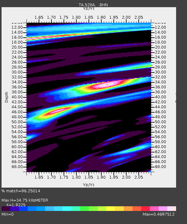
| Estimated Moho Depth: |
34.75 km |
| Estimated Crust Vp/Vs: |
1.92 |
| Assumed Crust Vp: |
6.121 km/s |
| Estimated Crust Vs: |
3.184 km/s |
| Estimated Crust Poisson's Ratio: |
0.31 |
|
| Radial Match: |
96.25014 % |
| Radial Bump: |
328 |
| Transverse Match: |
86.52203 % |
| Transverse Bump: |
400 |
| SOD ConfigId: |
2658 |
| Insert Time: |
2010-03-06 09:58:27.166 +0000 |
| GWidth: |
2.5 |
| Max Bumps: |
400 |
| Tol: |
0.001 |
|
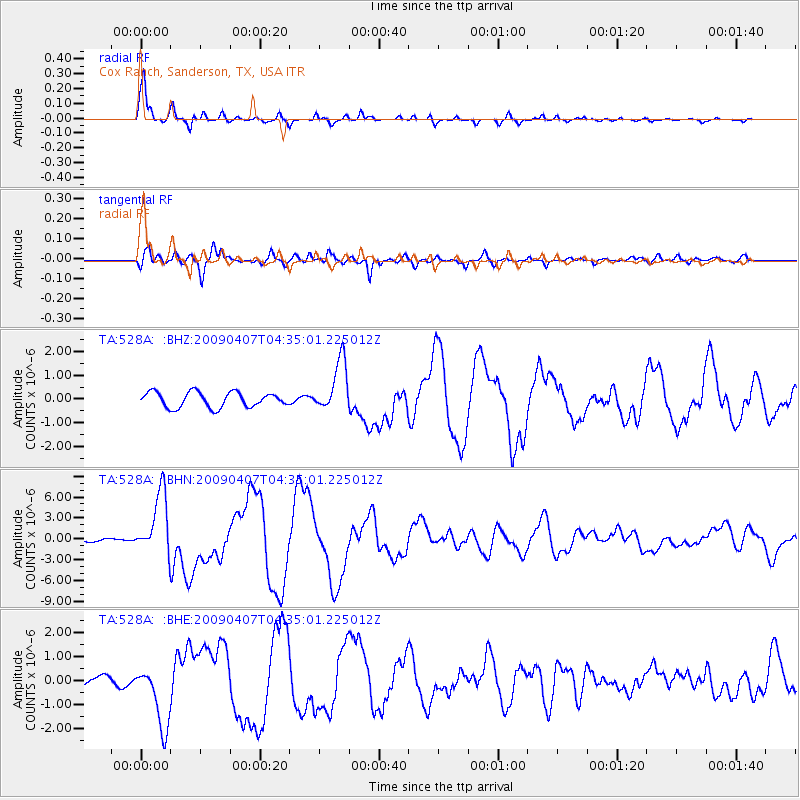
Signal To Noise
| Channel | StoN | STA | LTA |
| TA:528A: :BHN:20090407T04:35:01.225012Z | 14.4203415 | 4.5422967E-6 | 3.149923E-7 |
| TA:528A: :BHE:20090407T04:35:01.225012Z | 6.49643 | 1.3307922E-6 | 2.0484977E-7 |
| TA:528A: :BHZ:20090407T04:35:01.225012Z | 3.4169211 | 1.0897015E-6 | 3.189133E-7 |
| Arrivals |
| Ps | 5.4 SECOND |
| PpPs | 16 SECOND |
| PsPs/PpSs | 22 SECOND |


