You are here: Home > Network List > TA - USArray Transportable Network (new EarthScope stations) Stations List
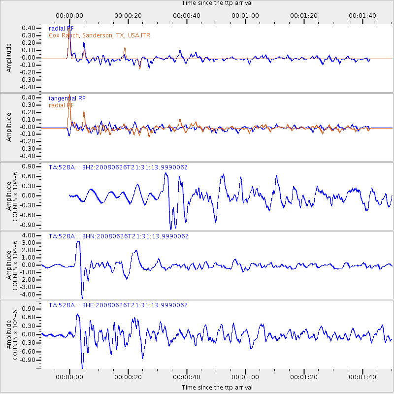
> Station 528A Cox Ranch, Sanderson, TX, USA > Earthquake Result Viewer
528A Cox Ranch, Sanderson, TX, USA - Earthquake Result Viewer
| Earthquake location: |
Tonga Islands |
| Earthquake latitude/longitude: |
-20.8/-173.3 |
| Earthquake time(UTC): |
2008/06/26 (178) 21:19:15 GMT |
| Earthquake Depth: |
38 km |
| Earthquake Magnitude: |
6.0 MB, 5.8 MS, 6.2 MW, 6.1 MW |
| Earthquake Catalog/Contributor: |
WHDF/NEIC |
|
| Network: |
TA USArray Transportable Network (new EarthScope stations) |
| Station: |
528A Cox Ranch, Sanderson, TX, USA |
| Lat/Lon: |
30.16 N/102.79 W |
| Elevation: |
1183 m |
|
| Distance: |
84.6 deg |
| Az: |
55.112 deg |
| Baz: |
242.414 deg |
| Ray Param: |
0.0452901 |
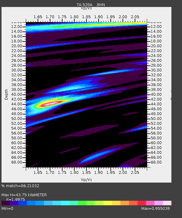
| Estimated Moho Depth: |
43.75 km |
| Estimated Crust Vp/Vs: |
1.70 |
| Assumed Crust Vp: |
6.121 km/s |
| Estimated Crust Vs: |
3.606 km/s |
| Estimated Crust Poisson's Ratio: |
0.23 |
|
| Radial Match: |
86.21032 % |
| Radial Bump: |
385 |
| Transverse Match: |
81.00743 % |
| Transverse Bump: |
400 |
| SOD ConfigId: |
2504 |
| Insert Time: |
2010-03-06 09:58:42.743 +0000 |
| GWidth: |
2.5 |
| Max Bumps: |
400 |
| Tol: |
0.001 |
|
Signal To Noise
| Channel | StoN | STA | LTA |
| TA:528A: :BHN:20080626T21:31:13.999006Z | 16.585085 | 2.0961966E-6 | 1.2639046E-7 |
| TA:528A: :BHE:20080626T21:31:13.999006Z | 7.9470997 | 5.0021424E-7 | 6.2942995E-8 |
| TA:528A: :BHZ:20080626T21:31:13.999006Z | 3.5244658 | 4.706253E-7 | 1.3353096E-7 |
| Arrivals |
| Ps | 5.1 SECOND |
| PpPs | 19 SECOND |
| PsPs/PpSs | 24 SECOND |


