You are here: Home > Network List > IU - Global Seismograph Network (GSN - IRIS/USGS) Stations List
> Station POHA Pohakuloa, Hawaii, USA > Earthquake Result Viewer
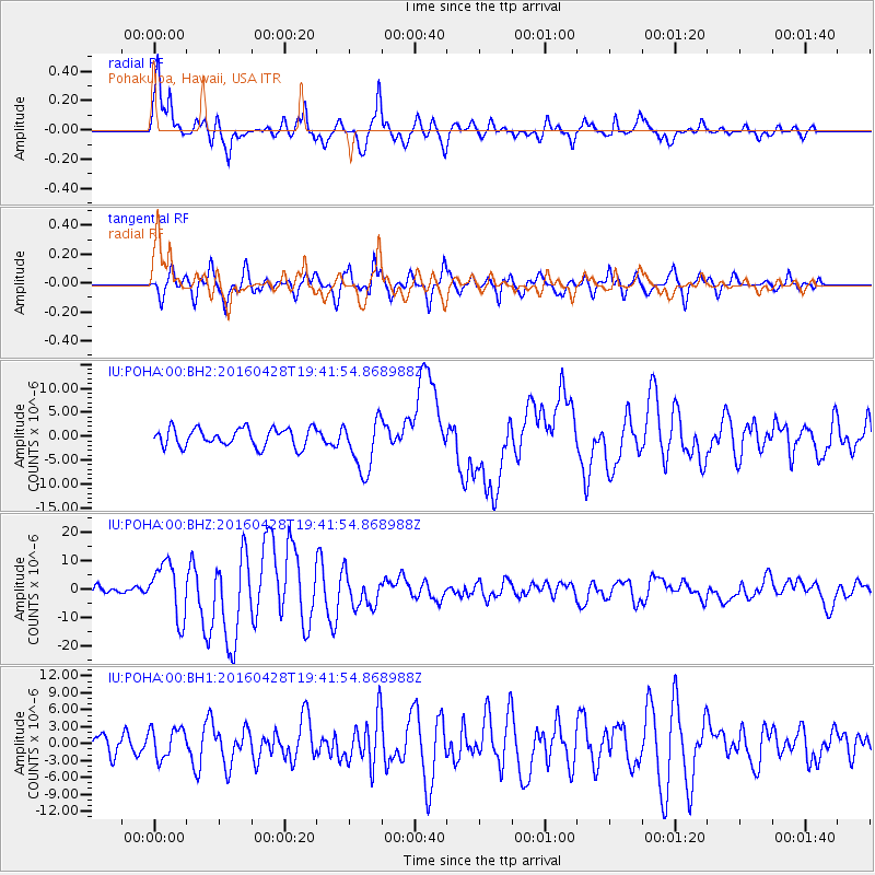
POHA Pohakuloa, Hawaii, USA - Earthquake Result Viewer

| Earthquake location: |
Vanuatu Islands |
| Earthquake latitude/longitude: |
-16.1/167.3 |
| Earthquake time(UTC): |
2016/04/28 (119) 19:33:27 GMT |
| Earthquake Depth: |
35 km |
| Earthquake Magnitude: |
7.0 MO |
| Earthquake Catalog/Contributor: |
NEIC PDE/NEIC ALERT |
|
| Network: |
IU Global Seismograph Network (GSN - IRIS/USGS) |
| Station: |
POHA Pohakuloa, Hawaii, USA |
| Lat/Lon: |
19.76 N/155.53 W |
| Elevation: |
1990 m |
|
| Distance: |
51.0 deg |
| Az: |
47.014 deg |
| Baz: |
228.299 deg |
| Ray Param: |
0.06761967 |
| Estimated Moho Depth: |
69.0 km |
| Estimated Crust Vp/Vs: |
1.72 |
| Assumed Crust Vp: |
5.195 km/s |
| Estimated Crust Vs: |
3.029 km/s |
| Estimated Crust Poisson's Ratio: |
0.24 |
|
| Radial Match: |
83.63544 % |
| Radial Bump: |
400 |
| Transverse Match: |
66.020424 % |
| Transverse Bump: |
400 |
| SOD ConfigId: |
1475611 |
| Insert Time: |
2016-05-12 20:02:43.507 +0000 |
| GWidth: |
2.5 |
| Max Bumps: |
400 |
| Tol: |
0.001 |
|
Signal To Noise
| Channel | StoN | STA | LTA |
| IU:POHA:00:BHZ:20160428T19:41:54.868988Z | 3.7927752 | 9.594382E-6 | 2.529647E-6 |
| IU:POHA:00:BH1:20160428T19:41:54.868988Z | 0.6531416 | 2.6976568E-6 | 4.1302783E-6 |
| IU:POHA:00:BH2:20160428T19:41:54.868988Z | 2.9016879 | 5.5832506E-6 | 1.924139E-6 |
| Arrivals |
| Ps | 9.9 SECOND |
| PpPs | 35 SECOND |
| PsPs/PpSs | 45 SECOND |


