You are here: Home > Network List > TA - USArray Transportable Network (new EarthScope stations) Stations List
> Station 528A Cox Ranch, Sanderson, TX, USA > Earthquake Result Viewer
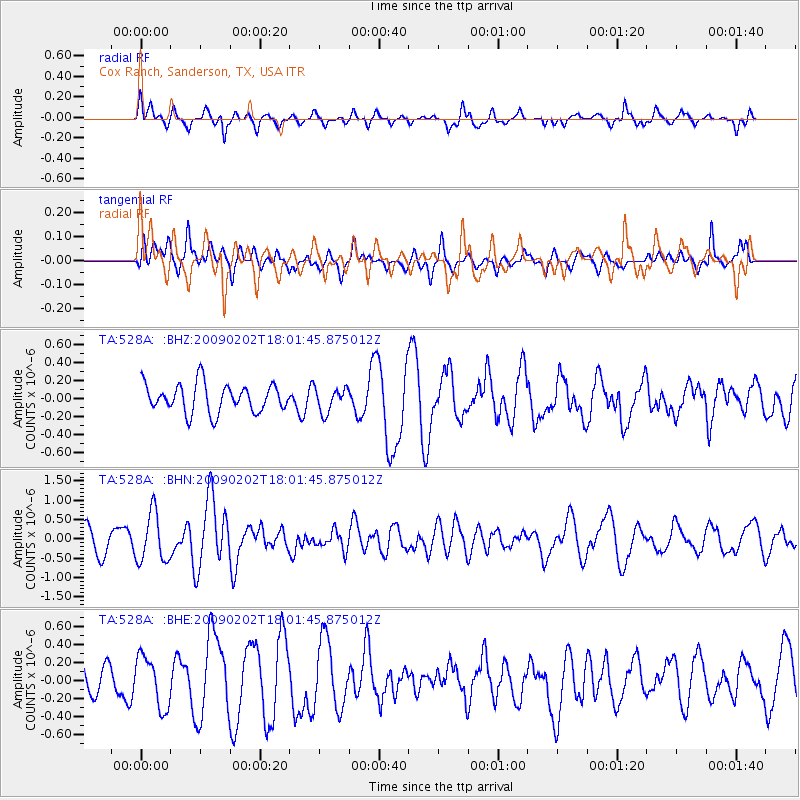
528A Cox Ranch, Sanderson, TX, USA - Earthquake Result Viewer
*The percent match for this event was below the threshold and hence no stack was calculated.
| Earthquake location: |
Near Coast Of Peru |
| Earthquake latitude/longitude: |
-13.6/-76.6 |
| Earthquake time(UTC): |
2009/02/02 (033) 17:53:21 GMT |
| Earthquake Depth: |
21 km |
| Earthquake Magnitude: |
5.6 MB, 5.6 MS, 6.0 MW, 5.9 MW |
| Earthquake Catalog/Contributor: |
WHDF/NEIC |
|
| Network: |
TA USArray Transportable Network (new EarthScope stations) |
| Station: |
528A Cox Ranch, Sanderson, TX, USA |
| Lat/Lon: |
30.16 N/102.79 W |
| Elevation: |
1183 m |
|
| Distance: |
50.3 deg |
| Az: |
330.164 deg |
| Baz: |
146.041 deg |
| Ray Param: |
$rayparam |
*The percent match for this event was below the threshold and hence was not used in the summary stack. |
|
| Radial Match: |
56.767956 % |
| Radial Bump: |
376 |
| Transverse Match: |
54.216774 % |
| Transverse Bump: |
400 |
| SOD ConfigId: |
6627 |
| Insert Time: |
2010-03-06 09:59:37.752 +0000 |
| GWidth: |
2.5 |
| Max Bumps: |
400 |
| Tol: |
0.001 |
|
Signal To Noise
| Channel | StoN | STA | LTA |
| TA:528A: :BHN:20090202T18:01:45.875012Z | 1.6341561 | 6.4067115E-7 | 3.9205017E-7 |
| TA:528A: :BHE:20090202T18:01:45.875012Z | 1.1438878 | 2.8494145E-7 | 2.4909914E-7 |
| TA:528A: :BHZ:20090202T18:01:45.875012Z | 0.8570212 | 1.3542174E-7 | 1.5801447E-7 |
| Arrivals |
| Ps | |
| PpPs | |
| PsPs/PpSs | |


