You are here: Home > Network List > TA - USArray Transportable Network (new EarthScope stations) Stations List
> Station B18K Kokolik River, AK, USA > Earthquake Result Viewer
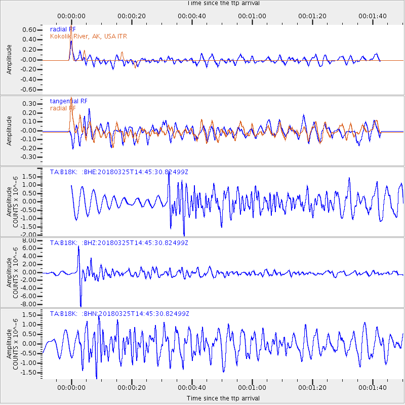
B18K Kokolik River, AK, USA - Earthquake Result Viewer
*The percent match for this event was below the threshold and hence no stack was calculated.
| Earthquake location: |
Southeast Of Honshu, Japan |
| Earthquake latitude/longitude: |
32.6/140.6 |
| Earthquake time(UTC): |
2018/03/25 (084) 14:37:23 GMT |
| Earthquake Depth: |
51 km |
| Earthquake Magnitude: |
5.7 Mww |
| Earthquake Catalog/Contributor: |
NEIC PDE/us |
|
| Network: |
TA USArray Transportable Network (new EarthScope stations) |
| Station: |
B18K Kokolik River, AK, USA |
| Lat/Lon: |
69.36 N/161.80 W |
| Elevation: |
222 m |
|
| Distance: |
48.6 deg |
| Az: |
23.522 deg |
| Baz: |
251.859 deg |
| Ray Param: |
$rayparam |
*The percent match for this event was below the threshold and hence was not used in the summary stack. |
|
| Radial Match: |
62.81429 % |
| Radial Bump: |
400 |
| Transverse Match: |
58.482372 % |
| Transverse Bump: |
400 |
| SOD ConfigId: |
13570011 |
| Insert Time: |
2019-04-30 00:24:29.499 +0000 |
| GWidth: |
2.5 |
| Max Bumps: |
400 |
| Tol: |
0.001 |
|
Signal To Noise
| Channel | StoN | STA | LTA |
| TA:B18K: :BHZ:20180325T14:45:30.82499Z | 9.480262 | 2.9099447E-6 | 3.0694773E-7 |
| TA:B18K: :BHN:20180325T14:45:30.82499Z | 1.1963643 | 5.87387E-7 | 4.909767E-7 |
| TA:B18K: :BHE:20180325T14:45:30.82499Z | 1.5643027 | 6.727881E-7 | 4.3008816E-7 |
| Arrivals |
| Ps | |
| PpPs | |
| PsPs/PpSs | |


